Filter: Categories of Wisconsin Historical Images
Filter: FULL_DATE of 1890
Filter: Community of Superior
Filter: Subject of transportation
Filter: Categories of Wisconsin Historical Images
Filter: FULL_DATE of 1890
Filter: Community of Superior
Filter: Subject of transportation

| Date: | 1890 |
|---|---|
| Description: | Bird's-eye map of West Superior and Superior, with insets of Wright Farm and First Building in Superior. |
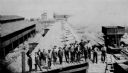
| Date: | 1890 |
|---|---|
| Description: | Elevated view of the coke ovens at the Lehigh Coal and Iron Company. A group of men are posing in the foreground. |
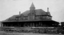
| Date: | 1890 |
|---|---|
| Description: | Exterior view from across street of Roosevelt Terrace apartments. |

| Date: | 1890 |
|---|---|
| Description: | This map of Superior shows labeled streets, railroads, docks, city wards, and the state line. Relief is shown by hachures. Below the title reads: "Bedford ... |

| Date: | 1890 |
|---|---|
| Description: | This map of Superior shows city wards, bays, docks, some businesses and points of interest. Relief is shown by hachures. The back of the map features a typ... |

| Date: | 1890 |
|---|---|
| Description: | This map shows lot and block numbers, established dock lines, docks, slips, railroads, streets, selected industrial buildings, sites for manufactories, and... |
If you didn't find the material you searched for, our Library Reference Staff can help.
Call our reference desk at 608-264-6535 or email us at: