 Filter: Categories of Wisconsin Historical Images
Filter: FULL_DATE of 1890
Filter: Creator Name of Unknown
Filter: Categories of Wisconsin Historical Images
Filter: FULL_DATE of 1890
Filter: Creator Name of Unknown

| Date: | 1890 |
|---|---|
| Description: | This 1890s map shows the Wisconsin Central Railroad land grant lands owned and for sale by the Soo Line in Ashland County, Wisconsin, as well as in the eas... |

| Date: | 1890 |
|---|---|
| Description: | View from the shore of Kenosha's North Pier and lighthouse. Waves are breaking on the shore of Lake Michigan. |

| Date: | 1890 |
|---|---|
| Description: | Shows towns of Dane County, lakes, rivers, and railroads. Relief shown by hachures. Includes color illustration of Madison and text describing Dane County ... |

| Date: | 1890 |
|---|---|
| Description: | This late-19th century map of Dane County, Wisconsin, shows the township and range grid, towns, sections, cities and villages, lakes and streams, roads, an... |

| Date: | 1890 |
|---|---|
| Description: | This map of Douglas County, Wisconsin, published around the beginning of the 20th century shows the copper bearing formations in the county on a map that a... |
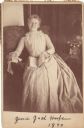
| Date: | 1890 |
|---|---|
| Description: | Cabinet card of an informal full-length portrait. (Mrs. Ben) Jessie Jack Hooper relaxes in a chair. The portrait may have been taken at the Sawyer House in... |
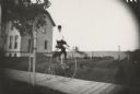
| Date: | 1890 |
|---|---|
| Description: | Young man riding a High Wheel or Penny-Farthing bicycle on a wooden sidewalk. There is a house behind the rider on the left. A young tree braced with a sta... |

| Date: | 1890 |
|---|---|
| Description: | Map of Milwaukee as remembered by "Dr Enoch Chase, U.B. Smith & Others." Represented are major roads, lowlands, trails, homesteads, and lots. Map depicts t... |

| Date: | 1890 |
|---|---|
| Description: | Map shows St. Croix, Wisconsin and a small portion of Taylor's Falls, Minnesota. Map reads: "The Lands shaded show the Mill & Riparian Reservation & unplat... |
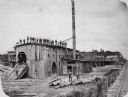
| Date: | 1890 |
|---|---|
| Description: | Men pose on top of and in front of the Spaulding, Van Hoosier & Company Sawmill. |
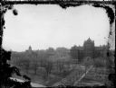
| Date: | 1890 |
|---|---|
| Description: | Elevated view along Langdon Street towards Science Hall on Bascom Hill at the University of Wisconsin-Madison. On the opposite side of Bascom Hill is Music... |
| Date: | 1890 |
|---|---|
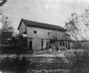
| Description: | Herling Saw Mill and Dam Southeast elevation. |
| Date: | 1890 |
|---|---|
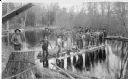
| Description: | View from shoreline of a driving crew standing on a log raft on the North Branch of the Popple River, a tributary of the Pine River. They are holding long ... |

| Date: | 1890 |
|---|---|
| Description: | Hotel dining room, probably at the Galloway House. |

| Date: | 1890 |
|---|---|
| Description: | This map of Superior shows labeled streets, railroads, docks, city wards, and the state line. Relief is shown by hachures. Below the title reads: "Bedford ... |

| Date: | 1890 |
|---|---|
| Description: | This map of Superior shows city wards, bays, docks, some businesses and points of interest. Relief is shown by hachures. The back of the map features a typ... |

| Date: | 1890 |
|---|---|
| Description: | This is a plat map of "Wauzeeka" drawn in pencil. The map shows numbered lots, labeled streets, the Kickapoo River, and railroads. The map reads: "Laid out... |
| Date: | 1890 |
|---|---|
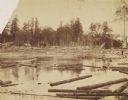
| Description: | 90,000 feet of pine logs floating in the storage/sorting pond at the Arpin Lumber Company sawmill. The sawmill and other buildings are in the background. O... |
| Date: | 1890 |
|---|---|
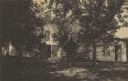
| Description: | The “loggery” cottage built for James Duane Doty. |
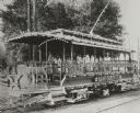
| Date: | 1890 |
|---|---|
| Description: | Special open streetcar called the MARGUERITE, with elaborate lighting, decorations, movable chairs and other features. |
If you didn't find the material you searched for, our Library Reference Staff can help.
Call our reference desk at 608-264-6535 or email us at: