Filter: Categories of Wisconsin Historical Images
Filter: FULL_DATE of 1889
Filter: Subject of lakes
Filter: Categories of Wisconsin Historical Images
Filter: FULL_DATE of 1889
Filter: Subject of lakes

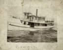
| Date: | 1889 |
|---|---|
| Description: | From a map published by Angell and Hastreither, the drawing depicts the Tonyawatha Spring Hotel grounds on Lake Monona. The hotel, located in Blooming Grov... |

| Date: | 1889 |
|---|---|
| Description: | This 1889 map of Douglas County, Wisconsin, shows the township and range grid, towns, sections, cities and villages, roads, existing and proposed railroads... |

| Date: | 1889 |
|---|---|
| Description: | Shows city limits, railroads, mills, schools, cemeteries, dams, parks, lumber yards, log canals, log reservoir, Chippewa River, Eau Claire River, and Half ... |

| Date: | 1889 |
|---|---|
| Description: | This map shows a plat of city, city limits, numbered blocks, numbered lots, wards, local streets, roads, railroads, street railways, fire limits, hydrants,... |
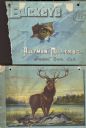
| Date: | 1889 |
|---|---|
| Description: | Front and back cover of catalog for harvesting machines. Front contains illustration of a torn hole with the eye of a buck looking through the hole. Superi... |
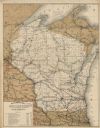
| Date: | 1889 |
|---|---|
| Description: | This map shows lakes, railroads, and rivers. An explanation of railroad lines with mileage in Wisconsin and total mileage for 1889 is included. Portions of... |
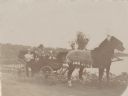
| Date: | 1889 |
|---|---|
| Description: | A family posing in an open carriage pulled by a matched team of horses on the shore of Rock Lake near Lake Mills. A handwritten caption identifies the fami... |
If you didn't find the material you searched for, our Library Reference Staff can help.
Call our reference desk at 608-264-6535 or email us at: