 Filter: Categories of Wisconsin Historical Images
Filter: FULL_DATE of 1888
Filter: Subject of industries
Filter: Categories of Wisconsin Historical Images
Filter: FULL_DATE of 1888
Filter: Subject of industries
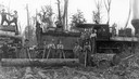
| Date: | 1888 |
|---|---|
| Description: | A logging crew of the Upham Lumber Company, together with the company's locomotive, "Old Vanderbilt," formerly the Wisconsin Central Railroad's Engine No #... |
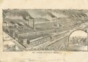
| Date: | 1888 |
|---|---|
| Description: | Engraving of the factory of William Deering and Company with inset illustrations of men operating a horse-drawn grain binder and mower. |
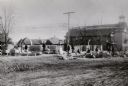
| Date: | 1888 |
|---|---|
| Description: | View across unpaved road towards construction workers at the site of the new city hall. William Waters, architect. |
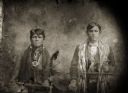
| Date: | 1888 |
|---|---|
| Description: | Copy photograph of a studio portrait of two young Ho-Chunk men posing standing and wearing regalia, including a finger-braided shawl on the man on the righ... |
| Date: | 1888 |
|---|---|
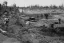
| Description: | Men working in Horlick's stone quarry. Teams of horses pull wagons. There is a steam pump at right. A man in a hat and coat, possibly William Horlick, stan... |

| Date: | 1888 |
|---|---|
| Description: | This late 19th century map of Price County, Wisconsin, shows landownership and waterfront acreages, the township and range system, towns, cities and villag... |
| Date: | 1888 |
|---|---|
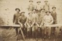
| Description: | Ed McDill's sawmill crew. Left to right: George Dickerman, George Norton, Charles Norton, Jesse Dickerman and, in a derby, Ed McDill, the owner. The boys a... |

| Date: | 1888 |
|---|---|
| Description: | This map has relief shown by hachures and features inset maps of a plat of E.D. Clinton and Blackwell’s add’n to the City of La Crosse. Wards (1-10) shaded... |

| Date: | 1888 |
|---|---|
| Description: | This map shows wards and includes the Chequamegon Bay and Washburn. An inset map shows the Ashland region, its railroads, and a few of its iron mines. |
| Date: | 1888 |
|---|---|
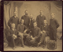
| Description: | Studio portrait in front of a painted backdrop of group of nine men, identified on the reverse as associates of the Geneva, New York Experiment Station. St... |

| Date: | 1888 |
|---|---|
| Description: | This is a reproduction of a map originally published in 1829 by R.W. Chandler, a pioneer settler of Galena. It is based on an earlier map by surveyor Luciu... |

| Date: | 1888 |
|---|---|
| Description: | View of three men standing together on the board sidewalk outside Kreuz and Curtis Shoes, 21 S. Pinckney Street. The men are wearing suits, ties and hats, ... |
If you didn't find the material you searched for, our Library Reference Staff can help.
Call our reference desk at 608-264-6535 or email us at: