 Filter: Categories of Wisconsin Historical Images
Filter: FULL_DATE of 1887
Filter: Subject of water
Filter: Categories of Wisconsin Historical Images
Filter: FULL_DATE of 1887
Filter: Subject of water
| Date: | 1887 |
|---|---|
| Description: | This map shows lakes, railroads, and rivers. An explanation of railroad lines with mileage in Wisconsin and total mileage for 1887 is included. Portions of... |

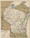
| Date: | 1887 |
|---|---|
| Description: | This map shows railroads, county boundaries, cities, towns, and waterways with relief shown by hachures. The prime meridians are: Greenwich and Washington.... |
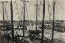
| Date: | 1887 |
|---|---|
| Description: | Caption reads: "Some of the Old-Timers on the Photo. Steamers: Petosky (on stocks), Muskegon, Corona, A.D. Hayward, City of St. Joe, Lotus, J.F. Dayan, Gra... |

| Date: | 1887 |
|---|---|
| Description: | A plat map of Waterford. Township 4, North Range 19, East of 4th Principal Meridian. References at bottom include school houses, houses, churches and cemet... |
If you didn't find the material you searched for, our Library Reference Staff can help.
Call our reference desk at 608-264-6535 or email us at: