 Filter: Categories of Wisconsin Historical Images
Filter: FULL_DATE of 1887
Filter: Subject of water
Filter: Categories of Wisconsin Historical Images
Filter: FULL_DATE of 1887
Filter: Subject of water

| Date: | 1887 |
|---|---|
| Description: | The bay shore of Menominee filled with driftwood. |
| Date: | 1887 |
|---|---|
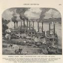
| Description: | Engraving of Pittsburg Landing taken from a photograph a few days after the Battle of Shiloh (Tennessee), which occurred on April 6-7, 1862. The image sho... |

| Date: | 1887 |
|---|---|
| Description: | This map shows block numbers, roads, railroads, wards, and selected buildings. The map includes a "Milwaukee city street guide" and index to public buildin... |

| Date: | 1887 |
|---|---|
| Description: | This 1887 manuscript map by Amidon G. Miller covers portions of the towns of Nelson and Stockholm in Pepin County, Wisconsin, as well as a portion of the T... |

| Date: | 1887 |
|---|---|
| Description: | This manuscript map of the southern portion of the Town of Porterfield, Marinette County, Wisconsin, shows sections and land ownership. The Menominee River... |

| Date: | 1887 |
|---|---|
| Description: | This 1887 map of Ashland County, Wisconsin, shows the township and range system, sections, railroads, vacant Wisconsin Central Railroad land, state and "go... |

| Date: | 1887 |
|---|---|
| Description: | This map shows mining properties in the Gogebic Range between Atkins Lake, in Sawyer County, Wisconsin, on the west and Lake Gogebic, Michigan, on the east... |

| Date: | 1887 |
|---|---|
| Description: | This 1887 map of Taylor County, Wisconsin, shows the township and range system, sections, railroads, vacant Wisconsin Central Railroad land, land sold by t... |

| Date: | 1887 |
|---|---|
| Description: | This 1896 map shows the township and range system, sections, cities and villages, railroads, roads, vacant land and land sold by the Wisconsin Central Rail... |

| Date: | 1887 |
|---|---|
| Description: | This late 19th century map shows the lake region around Oconomowoc in Waukesha County and eastern Jefferson County, Wisconsin. Cities and villages, roads, ... |
| Date: | 1887 |
|---|---|
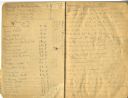
| Description: | Opening spread of Reuben Gold Thwaites' diary of his 1887 trip on the Fox River. |

| Date: | 1887 |
|---|---|
| Description: | Map of the Fox and Wisconsin Rivers to accompany Reuben Gold Thwaites' Historic Waterways. |
| Date: | 1887 |
|---|---|
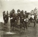
| Description: | Wisconsin National Guardsmen in full gear. One man in the foreground fills a tin cup from a spigot. |

| Date: | 1887 |
|---|---|
| Description: | City water works system map. Pencil annotation on the top right reads: "Period represented is after 1887 and before Aug. 1891". The middle of the map has a... |

| Date: | 1887 |
|---|---|
| Description: | Shows pipes of various sizes, hydrants with hydrant pressure, valves, wells, and projected lines. |

| Date: | 1887 |
|---|---|
| Description: | This etching by Amidon G. Miller covers portions of the towns of Nelson and Stockholm in Pepin County, Wisconsin, as well as a portion of the Town of Maide... |

| Date: | 1887 |
|---|---|
| Description: | This map of Tomahawk shows the Wisconsin River, numbered lots, and labeled streets. The back of the map reads: "Henry C. Payne, 424 Broadway, - - Milwaukee... |
| Date: | 1887 |
|---|---|
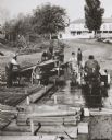
| Description: | A raft of lumber which has been floated down the Wisconsin River to be broken up and sold. Two men are standing on the raft, each near lumber stacked on a ... |

| Date: | 1887 |
|---|---|
| Description: | This map shows lot and block numbers, established dock lines, docks, slips, railroads, and streets of West Superior in 1887. |

| Date: | 1887 |
|---|---|
| Description: | This map shows sewers, manholes, streets, canals, rivers, and Lake Michigan. An explanation of sewer types is included. |
If you didn't find the material you searched for, our Library Reference Staff can help.
Call our reference desk at 608-264-6535 or email us at: