 Filter: Categories of Wisconsin Historical Images
Filter: FULL_DATE of 1887
Filter: Subject of water
Filter: Subject of human settlements
Filter: Categories of Wisconsin Historical Images
Filter: FULL_DATE of 1887
Filter: Subject of water
Filter: Subject of human settlements
| Date: | 1887 |
|---|---|
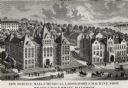
| Description: | Engraving of an elevated view of Science Hall, Chemical Laboratory and Machine Shop on the University of Wisconsin-Madison campus. |

| Date: | 1887 |
|---|---|
| Description: | Bird's-eye map of La Crosse, with six insets including residences, a store front, The John Gund Brewing Company, and C. & J. Michel Brewing Company. |

| Date: | 1887 |
|---|---|
| Description: | Bird's-eye view of Superior, on Lake Superior. |
| Date: | 1887 |
|---|---|
| Description: | Picnic Point from University Drive. |
| Date: | 1887 |
|---|---|
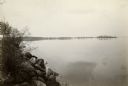
| Description: | View over Mississippi River of town on shoreline with bluff in the background. |
| Date: | 1887 |
|---|---|
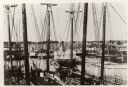
| Description: | Some of the Old-Timers in the photograph: Steamers: Petosky (on stocks), Muskegon, Corona, A.D. Hayward, City of St. Joe, Lotus, J.F. Dayan, Grace Willia... |

| Date: | 1887 |
|---|---|
| Description: | Benedict & Co. engineers. As shown by development to March 1st 1887. Inset: Map of northern Wisconsin showing location of range. Lands in red. |

| Date: | 1887 |
|---|---|
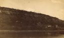
| Description: | View across water towards the Tonyawatha Spring Hotel on Lake Monona. The hotel, on the east shore of the lake, is located in Blooming Grove Township, just... |
| Date: | 1887 |
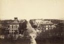
|---|---|
| Description: | Elevated view of Wisconsin Avenue from the Wisconsin State Capitol building. Mansions and churches are along the road, and Lake Mendota and Picnic Point ar... |
| Date: | 1887 |
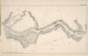
|---|---|
| Description: | A map of a portion of the Mississippi River from Marais D'Osier Lake (left) to Watertown. |

| Date: | 1887 |
|---|---|
| Description: | Men on shoreline are returning logs with horses, which have been stranded on a sandbar, to the main channel of the Mississippi River. Beef Slough Company w... |
| Date: | 1887 |
|---|---|
| Description: | A view at the mouth of the Menominee River showing Ludington Wells and Van Schaick's mills. |
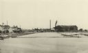
| Date: | 1887 |
|---|---|
| Description: | View of the boom company office and the site of the old trading post. |

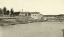
| Date: | 1887 |
|---|---|
| Description: | The Ramsay & Jones Mill with logs in the water in the foreground. |

| Date: | 1887 |
|---|---|
| Description: | Mill workers in the yard at Ramsay & Jones Mill. |

| Date: | 1887 |
|---|---|
| Description: | A bird's-eye map of Menekaune, Menominee and Marinette. |

| Date: | 1887 |
|---|---|
| Description: | The bay shore of Menominee filled with driftwood. |

| Date: | 1887 |
|---|---|
| Description: | This map shows block numbers, roads, railroads, wards, and selected buildings. The map includes a "Milwaukee city street guide" and index to public buildin... |

| Date: | 1887 |
|---|---|
| Description: | This 1887 manuscript map by Amidon G. Miller covers portions of the towns of Nelson and Stockholm in Pepin County, Wisconsin, as well as a portion of the T... |

| Date: | 1887 |
|---|---|
| Description: | This manuscript map of the southern portion of the Town of Porterfield, Marinette County, Wisconsin, shows sections and land ownership. The Menominee River... |
If you didn't find the material you searched for, our Library Reference Staff can help.
Call our reference desk at 608-264-6535 or email us at: