 Filter: Categories of Wisconsin Historical Images
Filter: FULL_DATE of 1887
Filter: Subject of water
Filter: Creator Name of Unknown
Filter: Categories of Wisconsin Historical Images
Filter: FULL_DATE of 1887
Filter: Subject of water
Filter: Creator Name of Unknown
| Date: | 1887 |
|---|---|
| Description: | Picnic Point from University Drive. |
| Date: | 1887 |
|---|---|
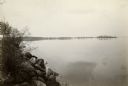
| Description: | View over Mississippi River of town on shoreline with bluff in the background. |
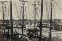
| Date: | 1887 |
|---|---|
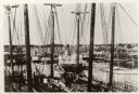
| Description: | Some of the Old-Timers in the photograph: Steamers: Petosky (on stocks), Muskegon, Corona, A.D. Hayward, City of St. Joe, Lotus, J.F. Dayan, Grace Willia... |

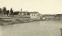
| Date: | 1887 |
|---|---|
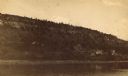
| Description: | View across water towards the Tonyawatha Spring Hotel on Lake Monona. The hotel, on the east shore of the lake, is located in Blooming Grove Township, just... |
| Date: | 1887 |
|---|---|
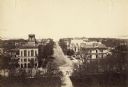
| Description: | Elevated view of Wisconsin Avenue from the Wisconsin State Capitol building. Mansions and churches are along the road, and Lake Mendota and Picnic Point ar... |
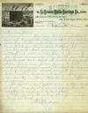
| Date: | 1887 |
|---|---|
| Description: | Letterhead of the La Crosse Wallis Carriage Co., manufacturers of fine family carriages, showing a view of the factory with the Mississippi River in the ba... |
| Date: | 1887 |
|---|---|
| Description: | A view at the mouth of the Menominee River showing Ludington Wells and Van Schaick's mills. |
| Date: | 1887 |
|---|---|
| Description: | View of the boom company office and the site of the old trading post. |

| Date: | 1887 |
|---|---|
| Description: | The Ramsay & Jones Mill with logs in the water in the foreground. |

| Date: | 1887 |
|---|---|
| Description: | Mill workers in the yard at Ramsay & Jones Mill. |

| Date: | 1887 |
|---|---|
| Description: | A bird's-eye map of Menekaune, Menominee and Marinette. |

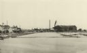
| Date: | 1887 |
|---|---|
| Description: | The bay shore of Menominee filled with driftwood. |

| Date: | 1887 |
|---|---|
| Description: | This manuscript map of the southern portion of the Town of Porterfield, Marinette County, Wisconsin, shows sections and land ownership. The Menominee River... |

| Date: | 1887 |
|---|---|
| Description: | Map of the Fox and Wisconsin Rivers to accompany Reuben Gold Thwaites' Historic Waterways. |

| Date: | 1887 |
|---|---|
| Description: | This map of Tomahawk shows the Wisconsin River, numbered lots, and labeled streets. The back of the map reads: "Henry C. Payne, 424 Broadway, - - Milwaukee... |
| Date: | 1887 |
|---|---|
| Description: | Caption reads: "Some of the Old-Timers on the Photo. Steamers: Petosky (on stocks), Muskegon, Corona, A.D. Hayward, City of St. Joe, Lotus, J.F. Dayan, Gra... |

| Date: | 1887 |
|---|---|
| Description: | A plat map of Waterford. Township 4, North Range 19, East of 4th Principal Meridian. References at bottom include school houses, houses, churches and cemet... |
If you didn't find the material you searched for, our Library Reference Staff can help.
Call our reference desk at 608-264-6535 or email us at: