 Filter: Categories of Wisconsin Historical Images
Filter: FULL_DATE of 1887
Filter: Reproduction Rights of For Sale
Filter: Categories of Wisconsin Historical Images
Filter: FULL_DATE of 1887
Filter: Reproduction Rights of For Sale
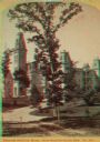
| Date: | 1887 |
|---|---|
| Description: | Stereograph. From the northeast (contrary to photographer's description.) A large tree is standing in the center along the drive, with the home behind it. |
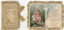
| Date: | 1887 |
|---|---|
| Description: | Valentine's Day card with tan fringe and tasseled cords. A border of white daisies surrounds a smaller zig-zag border. Inside the border is the text "St. V... |

| Date: | 1887 |
|---|---|
| Description: | Full-length cabinet card of two young children in front of a painted backdrop of the ocean. They are attired in coats, dresses and hats, and are holding ha... |
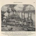
| Date: | 1887 |
|---|---|
| Description: | Engraving of Pittsburg Landing taken from a photograph a few days after the Battle of Shiloh (Tennessee), which occurred on April 6-7, 1862. The image sho... |

| Date: | 1887 |
|---|---|
| Description: | This map shows block numbers, roads, railroads, wards, and selected buildings. The map includes a "Milwaukee city street guide" and index to public buildin... |
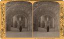
| Date: | 1887 |
|---|---|
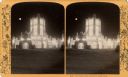
| Description: | A person is standing under the arched entrance of the Saint Paul Winter Carnival's ice palace. Inside the palace there is an ice animal sculpture on a plat... |
| Date: | 1887 |
|---|---|
| Description: | Stereograph of the south entrance of the Saint Paul Winter Carnival palace. |

| Date: | 1887 |
|---|---|
| Description: | This 1887 manuscript map by Amidon G. Miller covers portions of the towns of Nelson and Stockholm in Pepin County, Wisconsin, as well as a portion of the T... |

| Date: | 1887 |
|---|---|
| Description: | This manuscript map of the southern portion of the Town of Porterfield, Marinette County, Wisconsin, shows sections and land ownership. The Menominee River... |

| Date: | 1887 |
|---|---|
| Description: | This 1887 map of Price County, Wisconsin, shows the township and range system, sections, railroads, vacant land and land sold by the Wisconsin Central Rail... |

| Date: | 1887 |
|---|---|
| Description: | This 1887 map of Ashland County, Wisconsin, shows the township and range system, sections, railroads, vacant Wisconsin Central Railroad land, state and "go... |

| Date: | 1887 |
|---|---|
| Description: | This map shows mining properties in the Gogebic Range between Atkins Lake, in Sawyer County, Wisconsin, on the west and Lake Gogebic, Michigan, on the east... |

| Date: | 1887 |
|---|---|
| Description: | This 1887 map of Taylor County, Wisconsin, shows the township and range system, sections, railroads, vacant Wisconsin Central Railroad land, land sold by t... |

| Date: | 1887 |
|---|---|
| Description: | This 1896 map shows the township and range system, sections, cities and villages, railroads, roads, vacant land and land sold by the Wisconsin Central Rail... |

| Date: | 1887 |
|---|---|
| Description: | This late 19th century map shows the lake region around Oconomowoc in Waukesha County and eastern Jefferson County, Wisconsin. Cities and villages, roads, ... |
| Date: | 1887 |
|---|---|
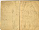
| Description: | Opening spread of Reuben Gold Thwaites' diary of his 1887 trip on the Fox River. |
| Date: | 1887 |
|---|---|
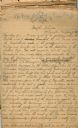
| Description: | First page of the Reuben Gold Thwaites' handwritten draft manuscript for his book Historic Waterways. |

| Date: | 1887 |
|---|---|
| Description: | Map of the Fox and Wisconsin Rivers to accompany Reuben Gold Thwaites' Historic Waterways. |
| Date: | 1887 |
|---|---|
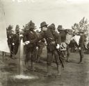
| Description: | Wisconsin National Guardsmen in full gear. One man in the foreground fills a tin cup from a spigot. |
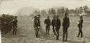
| Date: | 1887 |
|---|---|
| Description: | Wisconsin National Guardsmen standing in two rows for inspection. There are trees and bluffs in the background. |
If you didn't find the material you searched for, our Library Reference Staff can help.
Call our reference desk at 608-264-6535 or email us at: