 Filter: Categories of Wisconsin Historical Images
Filter: FULL_DATE of 1886
Filter: Subject of cities and towns
Filter: Categories of Wisconsin Historical Images
Filter: FULL_DATE of 1886
Filter: Subject of cities and towns
| Date: | 1886 |
|---|---|
| Description: | Color lithographed color advertising poster showing a McCormick grain binder at the Civil War battle of Gettysburg. The poster was based on a cyclorama by ... |

| Date: | 1886 |
|---|---|
| Description: | Bird's-eye view of Ashland, on the shores of Lake Superior, with insets of The Apostle Islands Chequamagon Bay & Ashland, and Distances from Ashland. |

| Date: | 1886 |
|---|---|
| Description: | This map shows U.S. land offices, completed railroads, railroad land grant limits, lakes, rivers, and Indian reservations. Communities, lakes, and rivers a... |
| Date: | 1886 |
|---|---|
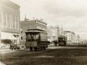
| Description: | First electric street railway service in Wisconsin. |

| Date: | 1886 |
|---|---|
| Description: | Bird's-eye view of Bayfield, county seat of Bayfield County. On the lower left side is an inset for Bayfield and the Apostle Islands. |
| Date: | 1886 |
|---|---|
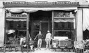
| Description: | Front view of C.F. Rau's furniture store, with the owners and employees sitting in front of the store. Apparently, the store also performs undertaking. The... |
| Date: | 1886 |
|---|---|
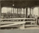
| Description: | View from inside of the Monona Lake Assembly Meeting Pavilion looking out on a large crowd of people. |

| Date: | 1886 |
|---|---|
| Description: | Bird's-eye map of Chippewa Falls, county seat of Chippewa Falls. |

| Date: | 1886 |
|---|---|
| Description: | Bird's-eye map of Hurley with insets Mining at the Colby, Hurley in 1885, and North Front of Silver Street. |

| Date: | 1886 |
|---|---|
| Description: | Cover of an advertising brochure for the Milwaukee Harvester Company featuring a color chromolithograph illustration of a farmer in a field operating a hor... |
| Date: | 1886 |
|---|---|
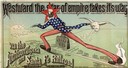
| Description: | Advertisement for the Atchison, Topeka and Santa Fe Railroad featuring an illustration of Uncle Sam stretched from the Missouri River to the Pacific Ocean.... |
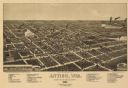
| Date: | 1886 |
|---|---|
| Description: | Bird's-eye map of Antigo, county Seat of Langlade County, population 2500. |

| Date: | 1886 |
|---|---|
| Description: | Bird's-eye map of Menomonee Falls. |

| Date: | 1886 |
|---|---|
| Description: | Bird's-eye map of Washburn on Lake Superior. There is an inset of Washburn, Chequamagon and the Apostle Islands. |

| Date: | 1886 |
|---|---|
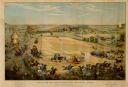
| Description: | Bird's-eye view of Milwaukee from Bay View. |

| Date: | 1886 |
|---|---|
| Description: | Bird's-eye map of Baraboo with inset of Devil's Lake, the south and east sides of the commercial square, the First National Bank, and the Warren House hote... |
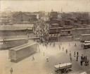
| Date: | 1886 |
|---|---|
| Description: | Elevated view of factory workers entering the Oakley Avenue gate of the McCormick Reaper Works. The men are filing in from the street, passing railroad box... |
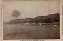
| Date: | 1886 |
|---|---|
| Description: | View of the Mississippi River from Alma. Caption reads: "Mississippi River. Ice Palace and Cyclone Views." |
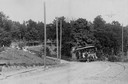
| Date: | 1886 |
|---|---|
| Description: | The first electric street railway in Wisconsin. |
If you didn't find the material you searched for, our Library Reference Staff can help.
Call our reference desk at 608-264-6535 or email us at:
