 Filter: Categories of Wisconsin Historical Images
Filter: FULL_DATE of 1886
Filter: Subject of church buildings
Filter: Categories of Wisconsin Historical Images
Filter: FULL_DATE of 1886
Filter: Subject of church buildings

| Date: | 1886 |
|---|---|
| Description: | Bird's-eye view of Bayfield, county seat of Bayfield County. On the lower left side is an inset for Bayfield and the Apostle Islands. |

| Date: | 1886 |
|---|---|
| Description: | Bird's-eye map of Menomonee Falls. |
| Date: | 1886 |
|---|---|
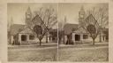
| Description: | Stereograph of the First Unitarian Church, which stood on Wisconsin Avenue near the Post Office. |
| Date: | 1886 |
|---|---|
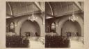
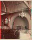
| Description: | Stereograph of the interior of the First Unitarian Church, which stood on Wisconsin Avenue near the Post Office. |
| Date: | 1886 |
|---|---|
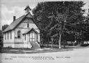
| Description: | View across road toward the First Christian Science Church entrance and left side. Vertical siding covers the structure, and latticework and chevron stripe... |
| Date: | 1886 |
|---|---|
| Description: | Stereograph of the interior of the First Unitarian Church, which stood on Wisconsin Avenue near the Post Office. |

| Date: | 1886 |
|---|---|
| Description: | A hand-colored map of Milwaukee County, Wisconsin that shows the township and range system, sections, towns, roads, railroads and rail stations, cities and... |
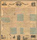
| Date: | 1886 |
|---|---|
| Description: | This 1886 map of Saint Croix County, Wisconsin, shows the township and range grid, sections, towns, cities and villages, land ownership and acreages, wagon... |

| Date: | 1886 |
|---|---|
| Description: | This map has relief shown by hachures and includes a list of plats in order of date of record, laws which vacate plats, plats not shown as upon the county ... |

| Date: | 1886 |
|---|---|
| Description: | Panoramic drawing of Madison, looking from the University toward the Wisconsin State Capitol. Among the locations identified along the border of the image ... |
If you didn't find the material you searched for, our Library Reference Staff can help.
Call our reference desk at 608-264-6535 or email us at: