Filter: Categories of Wisconsin Historical Images
Filter: FULL_DATE of 1886
Filter: County of Milwaukee
Filter: Subject of human settlements
Filter: Categories of Wisconsin Historical Images
Filter: FULL_DATE of 1886
Filter: County of Milwaukee
Filter: Subject of human settlements

| Date: | 1886 |
|---|---|
| Description: | Cover of an advertising brochure for the Milwaukee Harvester Company featuring a color chromolithograph illustration of a farmer in a field operating a hor... |

| Date: | 1886 |
|---|---|
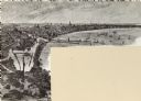
| Description: | Bird's-eye view of Milwaukee from Bay View. |
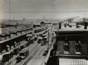
| Date: | 1886 |
|---|---|
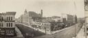
| Description: | Elevated view taken from the Miller Building, which is the original site of the old Milwaukee House. In the center of the foreground is what used to be ca... |
| Date: | 1886 |
|---|---|
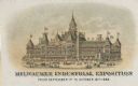
| Description: | Print advertising the Milwaukee Industrial Exposition. View of building with flags flying from almost every peak on the the roof. Pedestrians and horse-dra... |

| Date: | 1886 |
|---|---|
| Description: | Detail of map including plans of the National Soldiers' home. |
| Date: | 1886 |
|---|---|
| Description: | Stereograph. Located on Oneida Street, the opera house is three stories tall, and located across the street from a pharmacy (the Rx sign is hanging above t... |
| Date: | 1886 |
|---|---|
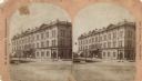
| Description: | Elevated view of Reed Street from the corner of South Water Street. This depot served the Chicago, Milwaukee and St. Paul, the Wisconsin Central, and the M... |
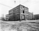
| Date: | 1886 |
|---|---|
| Description: | Exterior view of one of the first Pawling & Harnischfeger machine shops. The building was built in 1886 on the corner of South First Street and East Oregon... |
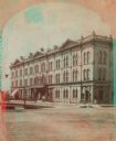
| Date: | 1886 |
|---|---|
| Description: | Stereograph. Located on Oneida Street, the opera house is three stories tall, and located across the street from a pharmacy (the Rx sign is hanging above t... |

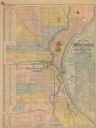
| Date: | 1886 |
|---|---|
| Description: | A hand-colored map of Milwaukee County, Wisconsin that shows the township and range system, sections, towns, roads, railroads and rail stations, cities and... |
| Date: | 1886 |
|---|---|
| Description: | The map reads: "Compiled under the direction of the J.V. DUPRE ABSTRACT CO. from Dupre’s 1/4 Sectn’l Atlas of Milwaukee, by G. Steinhagen, C.E." The map co... |
| Date: | 1886 |
|---|---|
| Description: | Two maps on one page. The first page is a map of Milwaukee County with insets "Plan of Pewaukee, Waukesha Co.," "Plan of Oconomowoc, Waukesha Co.," "Plan o... |

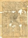
| Date: | 1886 |
|---|---|
| Description: | Map shows townships, post offices, roads, railroads, and selected buildings. The sections are in pink, green, blue, and yellow. Counties, towns, and lakes ... |
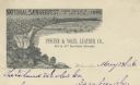
| Date: | 1886 |
|---|---|
| Description: | Letterhead for the Pfister & Vogel Leather Co., with an engraving of a bird's-eye view of the city (signed Ma-- Richards, Mil Wis) advertising the "Nationa... |

| Date: | 1886 |
|---|---|
| Description: | A group of soldiers posing in rows, some kneeling and holding their rifles. Caption reads: "May 1886 Co. F Wisconsin National Guard at Milwaukee riots." |
If you didn't find the material you searched for, our Library Reference Staff can help.
Call our reference desk at 608-264-6535 or email us at: