 Filter: Categories of Wisconsin Historical Images
Filter: FULL_DATE of 1885
Filter: Subject of superior, lake
Filter: Categories of Wisconsin Historical Images
Filter: FULL_DATE of 1885
Filter: Subject of superior, lake

| Date: | 1885 |
|---|---|
| Description: | View of the ore dock of the Milwaukee, Lake Shore, and Western Railroad. Large logs, buildings and a railroad bridge are in the foreground. |

| Date: | 1885 |
|---|---|
| Description: | Illustrated view of Superior, as well as Omaha, Kansas City, St. Paul, and Winnipeg. Caption reads: "Superior - The Last Possible Great Marine City in the ... |
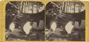
| Date: | 1885 |
|---|---|
| Description: | Stereograph of a sailboat in Excursion Cave, on Hemlock Island of the Apostle Islands. A man can be seen sitting in the boat. |
| Date: | 1885 |
|---|---|
| Description: | A hand-colored map of Wisconsin that also includes eastern Minnesota and Iowa, northern Illinois, and the Upper Peninsula of Michigan showing the counties,... |

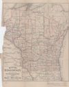
| Date: | 1885 |
|---|---|
| Description: | A hand-colored map of Wisconsin showing the railroads, counties, cities, towns, rivers, and lakes in the state. Also included in the map are the eastern po... |
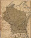
| Date: | 1885 |
|---|---|
| Description: | This map shows lakes, railroads, and rivers. An explanation of railroad lines with mileage in Wisconsin and total mileage for 1885 is included. Portions of... |
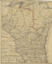
| Date: | 1885 |
|---|---|
| Description: | This map shows current and projected railroad lines. County boundaries in the state of Wisconsin are outlined in red. Included are portions of Iowa, Illino... |
If you didn't find the material you searched for, our Library Reference Staff can help.
Call our reference desk at 608-264-6535 or email us at: