 Filter: Categories of Wisconsin Historical Images
Filter: FULL_DATE of 1885
Filter: Subject of rivers
Filter: Categories of Wisconsin Historical Images
Filter: FULL_DATE of 1885
Filter: Subject of rivers

| Date: | 1885 |
|---|---|
| Description: | Bird's-eye view of Watertown with indexed points of interest. |

| Date: | 1885 |
|---|---|
| Description: | Bird's-eye map of Oconomowoc. |

| Date: | 1885 |
|---|---|
| Description: | Bird's-eye view of Sheboygan, with inset of J.J. Volrath Manufacturing Company. |

| Date: | 1885 |
|---|---|
| Description: | Bird's-eye map of Waupun on the Rock River. There is an inset at top center of "Althouse, Wheeler & Co., Windmills and Pumps." |

| Date: | 1885 |
|---|---|
| Description: | Bird's-eye map of Hustisford. |
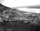
| Date: | 1885 |
|---|---|
| Description: | Elevated view looking south over Fountain City and river. |
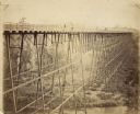
| Date: | 1885 |
|---|---|
| Description: | Elevated view of the Wiscsonsin Central's bridge over the White River, about six miles south of Ashland. The bridge was 1600 ft. long and 110 ft. above the... |
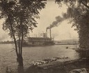
| Date: | 1885 |
|---|---|
| Description: | View from shoreline of the sternwheel steamer "E. Rutledge," owned by Weyerhaeuser & Denkmann's Rock Island Lumber Company, picking up a raft of logs at Be... |
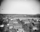
| Date: | 1885 |
|---|---|
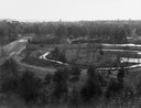
| Description: | Elevated view of the river and town. Probably prior to 1885 because the Van Schaick building/photograph gallery is not constructed on Second Street. |
| Date: | 1885 |
|---|---|
| Description: | Chippewa Falls with a park and river in the foreground. |
| Date: | 1885 |
|---|---|
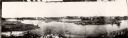
| Description: | A panoramic view of the east bank of the Wisconsin River from the Green Bay & Western Railway bridge to the wagon bridge. |

| Date: | 1885 |
|---|---|
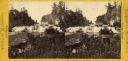
| Description: | Stereograph of Kinnikinnick Falls, the north branch. |
| Date: | 1885 |
|---|---|
| Description: | Stereograph of Kinnikinnick Falls, north branch. |
| Date: | 1885 |
|---|---|
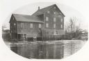
| Description: | Lemonweir River flour mill built in 1852 and torn down in 1943. Mill and site were purchased in 1926 by the Wisconsin Power and Light Company for a power p... |
| Date: | 1885 |
|---|---|
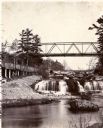
| Description: | View looking up river towards the Kinnickinnic Falls. A bridge is above the falls. |
| Date: | 1885 |
|---|---|
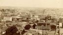
| Description: | Elevated view from tower of the Racine Court House looking north. A note at bottom center on the building of a roof reads, in part: "1st. Presby. Church. 1... |
| Date: | 1885 |
|---|---|
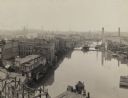
| Description: | Elevated view of river looking north from the Wisconsin Avenue Bridge. A pier with a small building and poster boards extends into the water from the bott... |
| Date: | 1885 |
|---|---|
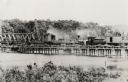
| Description: | Partial removal of railroad bridge over Rock River. A train is on a section not being removed in order to transport men and materials. |

| Date: | 1885 |
|---|---|
| Description: | Fire insurance map of the McCormick Reaper Works, a factory of the McCormick Harvesting Machine Company. |
If you didn't find the material you searched for, our Library Reference Staff can help.
Call our reference desk at 608-264-6535 or email us at:
