 Filter: Categories of Wisconsin Historical Images
Filter: FULL_DATE of 1885
Filter: Subject of railroads
Filter: Categories of Wisconsin Historical Images
Filter: FULL_DATE of 1885
Filter: Subject of railroads

| Date: | 1885 |
|---|---|
| Description: | Bird's-eye map of Madison, State Capital of Wisconsin, County Seat of Dane County, with inset of the Wisconsin State Capitol. |

| Date: | 1885 |
|---|---|
| Description: | Bird's-eye map of Oconomowoc. |

| Date: | 1885 |
|---|---|
| Description: | Bird's-eye map of Waupun on the Rock River. There is an inset at top center of "Althouse, Wheeler & Co., Windmills and Pumps." |

| Date: | 1885 |
|---|---|
| Description: | Ore dock of the Milwaukee, Lake Shore, and Western Railroad, with a pile of logs in the foreground and docked ships in the background. |

| Date: | 1885 |
|---|---|
| Description: | Illustrated view of Superior, as well as Omaha, Kansas City, St. Paul, and Winnipeg. Caption reads: "Superior - The Last Possible Great Marine City in the ... |
| Date: | 1885 |
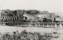
|---|---|
| Description: | Partial removal of railroad bridge over Rock River. A train is on a section not being removed in order to transport men and materials. |
| Date: | 1885 |
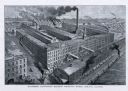
|---|---|
| Description: | Engraved bird's-eye view illustration of the "McCormick Harvesting Machine Company's Works," including railroad cars, smoke from smokestacks and factory wo... |

| Date: | 1885 |
|---|---|
| Description: | Fire insurance map of the McCormick Reaper Works, a factory of the McCormick Harvesting Machine Company. |
| Date: | 1885 |
|---|---|
| Description: | A hand-colored map of Wisconsin that also includes eastern Minnesota and Iowa, northern Illinois, and the Upper Peninsula of Michigan showing the counties,... |

| Date: | 1885 |
|---|---|
| Description: | A hand-colored map of Wisconsin showing the railroads, counties, cities, towns, rivers, and lakes in the state. Also included in the map are the eastern po... |
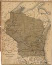
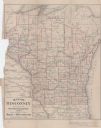
| Date: | 1885 |
|---|---|
| Description: | This map shows lakes, railroads, and rivers. An explanation of railroad lines with mileage in Wisconsin and total mileage for 1885 is included. Portions of... |
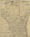
| Date: | 1885 |
|---|---|
| Description: | This map shows current and projected railroad lines. County boundaries in the state of Wisconsin are outlined in red. Included are portions of Iowa, Illino... |
If you didn't find the material you searched for, our Library Reference Staff can help.
Call our reference desk at 608-264-6535 or email us at: