 Filter: Categories of Wisconsin Historical Images
Filter: FULL_DATE of 1885
Filter: Subject of lakes
Filter: Categories of Wisconsin Historical Images
Filter: FULL_DATE of 1885
Filter: Subject of lakes
| Date: | 1885 |
|---|---|
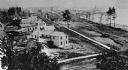
| Description: | South Pinckney Street between East Washington Avenue (left) and King Street (right). On the right is the Marquette neighborhood. The large structure at the... |

| Date: | 1885 |
|---|---|
| Description: | Mining and lumbering provided the impetus for the development of northern Wisconsin and Ashland was ideally situated to become a leading city of the "new W... |
| Date: | 1885 |
|---|---|
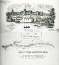
| Description: | Illustration of the exterior of the tourist resort Tonyawatha Spring Hotel (an earlier version was called Tonyawatha House) from across Lake Monona. There ... |

| Date: | 1885 |
|---|---|
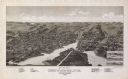
| Description: | Bird's-eye map of Madison, State Capital of Wisconsin, County Seat of Dane County, with inset of the Wisconsin State Capitol. |

| Date: | 1885 |
|---|---|
| Description: | Bird's-eye map of Oconomowoc. |

| Date: | 1885 |
|---|---|
| Description: | Bird's-eye view of Sheboygan, with inset of J.J. Volrath Manufacturing Company. |
| Date: | 1885 |
|---|---|
| Description: | Bird's-eye map of Whitewater with insets of points of interest. |
| Date: | 1885 |
|---|---|
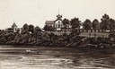
| Description: | View down pier towards shoreline and building at Lake Geneva at Montague's and Porter's resort, later W.F. Furbecks, at the site of Fontana Park or Buena V... |
| Date: | 1885 |
|---|---|
| Description: | Elevated view of Shell Lake looking towards the sawmills. |
| Date: | 1885 |
|---|---|
| Description: | From the cover of a descriptive brochure in the Historical Society's Library pamphlet collection, this drawing depicts the large hotel grounds on Lake Mono... |
| Date: | 1885 |
|---|---|
| Description: | View towards Lake Monona, with the Dane County Courthouse on the right. Text at bottom reads: "Curtiss Madison Wis." |
| Date: | 1885 |
|---|---|
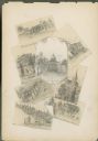
| Description: | Wisconsin State Capitol surrounded by seven miniature drawings of Madison images. |
| Date: | 1885 |
|---|---|
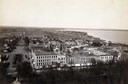
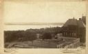
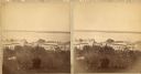
| Description: | A view of Lake Monona from the Capitol building, looking down King Street. |
| Date: | 1885 |
|---|---|
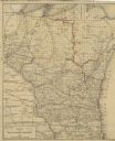
| Description: | A hand-colored map of Wisconsin that also includes eastern Minnesota and Iowa, northern Illinois, and the Upper Peninsula of Michigan showing the counties,... |

| Date: | 1885 |
|---|---|
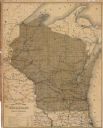
| Description: | A hand-colored map of Wisconsin showing the railroads, counties, cities, towns, rivers, and lakes in the state. Also included in the map are the eastern po... |

| Date: | 1885 |
|---|---|
| Description: | A detail of a Sanborn map showing the lake Mendota shore area, including Madison Manufacturing Company. |

| Date: | 1885 |
|---|---|
| Description: | A detail of a Sanborn map including Catfish Creek and Westport Road by Lake Mendota. |
| Date: | 1885 |
|---|---|
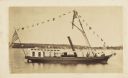
| Description: | Small steam yacht decorated with pennants on Lake Geneva. A small group is at the front of the yacht. Shoreline with boathouses and dwellings can be seen i... |
| Date: | 1885 |
|---|---|
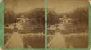
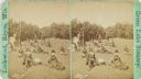
| Description: | Scattered figures of a picnic party on a grassy slope. |
| Date: | 1885 |
|---|---|
| Description: | This map shows lakes, railroads, and rivers. An explanation of railroad lines with mileage in Wisconsin and total mileage for 1885 is included. Portions of... |
If you didn't find the material you searched for, our Library Reference Staff can help.
Call our reference desk at 608-264-6535 or email us at: