 Filter: Categories of Wisconsin Historical Images
Filter: FULL_DATE of 1885
Filter: Subject of bridges
Filter: Categories of Wisconsin Historical Images
Filter: FULL_DATE of 1885
Filter: Subject of bridges

| Date: | 1885 |
|---|---|
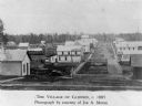
| Description: | Bird's-eye map of Oconomowoc. |

| Date: | 1885 |
|---|---|
| Description: | Bird's-eye view of Sheboygan, with inset of J.J. Volrath Manufacturing Company. |
| Date: | 1885 |
|---|---|
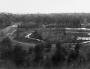
| Description: | Chippewa Falls with a park and river in the foreground. |
| Date: | 1885 |
|---|---|
| Description: | View of buildings in an industrial area with a forest in the background. |
| Date: | 1885 |
|---|---|
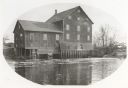
| Description: | Lemonweir River flour mill built in 1852 and torn down in 1943. Mill and site were purchased in 1926 by the Wisconsin Power and Light Company for a power p... |
| Date: | 1885 |
|---|---|
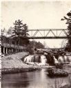
| Description: | View looking up river towards the Kinnickinnic Falls. A bridge is above the falls. |
| Date: | 1885 |
|---|---|
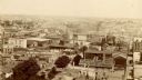
| Description: | Elevated view from tower of the Racine Court House looking north. A note at bottom center on the building of a roof reads, in part: "1st. Presby. Church. 1... |
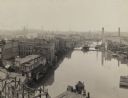
| Date: | 1885 |
|---|---|
| Description: | Elevated view of river looking north from the Wisconsin Avenue Bridge. A pier with a small building and poster boards extends into the water from the bott... |
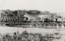
| Date: | 1885 |
|---|---|
| Description: | Partial removal of railroad bridge over Rock River. A train is on a section not being removed in order to transport men and materials. |

| Date: | 1885 |
|---|---|
| Description: | A detail of a Sanborn map including Catfish Creek and Westport Road by Lake Mendota. |
If you didn't find the material you searched for, our Library Reference Staff can help.
Call our reference desk at 608-264-6535 or email us at: