 Filter: Categories of Wisconsin Historical Images
Filter: FULL_DATE of 1885
Filter: Type of Map or Atlas
Filter: Categories of Wisconsin Historical Images
Filter: FULL_DATE of 1885
Filter: Type of Map or Atlas

| Date: | 1885 |
|---|---|
| Description: | Bird's-eye view of Watertown with indexed points of interest. |

| Date: | 1885 |
|---|---|
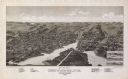
| Description: | Mining and lumbering provided the impetus for the development of northern Wisconsin and Ashland was ideally situated to become a leading city of the "new W... |

| Date: | 1885 |
|---|---|
| Description: | Bird's-eye map of Madison, State Capital of Wisconsin, County Seat of Dane County, with inset of the Wisconsin State Capitol. |

| Date: | 1885 |
|---|---|
| Description: | Bird's-eye map of Oconomowoc. |

| Date: | 1885 |
|---|---|
| Description: | Bird's-eye view of Sheboygan, with inset of J.J. Volrath Manufacturing Company. |
| Date: | 1885 |
|---|---|
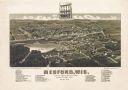
| Description: | Bird's-eye map of Medford, before the great fire of May 28, 1885. |

| Date: | 1885 |
|---|---|
| Description: | Bird's-eye map of Waupun on the Rock River. There is an inset at top center of "Althouse, Wheeler & Co., Windmills and Pumps." |
| Date: | 1885 |
|---|---|
| Description: | Bird's-eye map of Whitewater with insets of points of interest. |

| Date: | 1885 |
|---|---|
| Description: | Bird's-eye map of Hustisford. |

| Date: | 1885 |
|---|---|
| Description: | Fire insurance map of the McCormick Reaper Works, a factory of the McCormick Harvesting Machine Company. |
| Date: | 1885 |
|---|---|
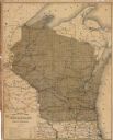
| Description: | A hand-colored map of Wisconsin that also includes eastern Minnesota and Iowa, northern Illinois, and the Upper Peninsula of Michigan showing the counties,... |
| Date: | 1885 |
|---|---|
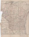
| Description: | Map of Wisconsin showing the populations of each county as well as the total population for the state. |

| Date: | 1885 |
|---|---|
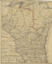
| Description: | A hand-colored map of Wisconsin showing the railroads, counties, cities, towns, rivers, and lakes in the state. Also included in the map are the eastern po... |

| Date: | 1885 |
|---|---|
| Description: | A detail of a Sanborn map showing the lake Mendota shore area, including Madison Manufacturing Company. |

| Date: | 1885 |
|---|---|
| Description: | A detail of a Sanborn map including Catfish Creek and Westport Road by Lake Mendota. |
| Date: | 1885 |
|---|---|
| Description: | This map shows lakes, railroads, and rivers. An explanation of railroad lines with mileage in Wisconsin and total mileage for 1885 is included. Portions of... |
| Date: | 1885 |
|---|---|
| Description: | This map shows current and projected railroad lines. County boundaries in the state of Wisconsin are outlined in red. Included are portions of Iowa, Illino... |
If you didn't find the material you searched for, our Library Reference Staff can help.
Call our reference desk at 608-264-6535 or email us at:
