 Filter: Categories of Wisconsin Historical Images
Filter: FULL_DATE of 1882
Filter: Creator Name of Unknown
Filter: Subject of land
Filter: Categories of Wisconsin Historical Images
Filter: FULL_DATE of 1882
Filter: Creator Name of Unknown
Filter: Subject of land
| Date: | 1882 |
|---|---|
| Description: | Map showing Indian Reservations in the United States. |
| Date: | 1882 |
|---|---|
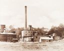
| Description: | First building of the 27th Street plant. |

| Date: | 1882 |
|---|---|
| Description: | The official railroad map of Wisconsin showing railroad lines throughout the state. |

| Date: | 1882 |
|---|---|
| Description: | A geological map of northern Wisconsin showing the locations of different soil types in the state such as sandy soil, sandy loam, prairie loam, clayey loam... |

| Date: | 1882 |
|---|---|
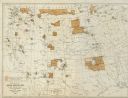
| Description: | This manuscript map from 1882 shows land use and land for sale in a portion of the Town of Pewaukee, Waukesha County, Wisconsin. Woods, marshland, springs,... |

| Date: | 1882 |
|---|---|
| Description: | This map is ink on cardboard and shows the location of military forts over the course of years. Also shown are points of interest, streets, the Mississippi... |
| Date: | 1882 |
|---|---|
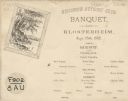
| Description: | Card menu for the Wisconsin Authors' Club Banquet at Klosterheim. On the top left is a framed landscape of trees overlooking a body of water. |
If you didn't find the material you searched for, our Library Reference Staff can help.
Call our reference desk at 608-264-6535 or email us at: