Filter: Categories of Wisconsin Historical Images
Filter: FULL_DATE of 1880
Filter: Subject of water
Filter: Subject of land
Filter: Categories of Wisconsin Historical Images
Filter: FULL_DATE of 1880
Filter: Subject of water
Filter: Subject of land
| Date: | 1880 |
|---|---|
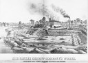
| Description: | Lithograph of the Milwaukee Cement Company's Works at 154 West Water Street in Milwaukee. |

| Date: | 1880 |
|---|---|
| Description: | Bird's-eye map of Waukesha, county seat of Waukesha County. |

| Date: | 1880 |
|---|---|
| Description: | Bird's-eye map over the Mississippi River of Fountain City. Paddle steamers and steamboats are on the river, and bluffs are in the background. |

| Date: | 1880 |
|---|---|
| Description: | Bird's-eye map of Neillsville, with inset. |
| Date: | 1880 |
|---|---|
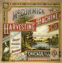
| Description: | Cover of a McCormick Harvesting Machine Company fair circular (catalog). The cover is illustrated with a lake and mountain scene and includes the text "Man... |
| Date: | 1880 |
|---|---|
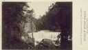
| Description: | Willow River Falls. Text at right reads: "Published by Whitney's Gallery, St. Paul, Minn. Willow River Falls Near Hudeson, Wis." |
| Date: | 1880 |
|---|---|
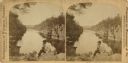
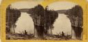
| Description: | Stereograph of the Dalles and the Saint Croix River, with one man in the center foreground sitting posing on a rock and looking to the left. On the far lef... |
| Date: | 1880 |
|---|---|
| Description: | Stereograph of the Dalles rock formation with a two men in the foreground looking down at the Saint Croix River. On the left, one man stands leaning agains... |
| Date: | 1880 |
|---|---|
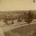
| Description: | The view of Red Cedar River from Meadow Hill. |

| Date: | 1880 |
|---|---|
| Description: | This map shows railroads by operator and projected railroads. Portions of Lake Michigan, Lake Superior, Illinois, Iowa, Michigan and Minnesota are labeled. |

| Date: | 1880 |
|---|---|
| Description: | Stereograph of the Dalles and the Saint Croix River with man in the foreground. |

| Date: | 1880 |
|---|---|
| Description: | A hand-colored map of the Chippewa, Price, Taylor and the northern part of Clark counties, which shows the locations of farmhouses, schoolhouses, churches,... |

| Date: | 1880 |
|---|---|
| Description: | Map of Wisconsin including the eastern portions on Minnesota, Iowa, northern Illinois, and the western most portion of Michigan’s Upper Peninsula, showing ... |

| Date: | 1880 |
|---|---|
| Description: | This copy of an 1834 map in the American Fur Company's papers held by the New-York Historical Society shows an outline of Chequamegon Bay and Madeline Isla... |

| Date: | 1880 |
|---|---|
| Description: | This 1880 map of Clark County, Wisconsin, shows the township and range grid, towns, sections, cities and villages, railroads, roads, rivers and lakes, dams... |
| Date: | 1880 |
|---|---|
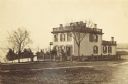
| Description: | View across lawn of the residence of Lucius Fairchild, in Madison. A woman is standing outdoors near the entrance. A fence surrounds the yard of the house,... |

| Date: | 1880 |
|---|---|
| Description: | This map of La Crosse shows the Chicago, Milwaukee and St. Paul Railroad, the Southern Minnesota Railroad and the Chicago, Dubuque and Minnesota Railroad, ... |
| Date: | 1880 |
|---|---|
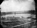
| Description: | View across water towards what is identified as the second railroad bridge at Black River Falls. Note the wood trestle on the right. |
If you didn't find the material you searched for, our Library Reference Staff can help.
Call our reference desk at 608-264-6535 or email us at: