Filter: Categories of Wisconsin Historical Images
Filter: FULL_DATE of 1880
Filter: Subject of rivers
Filter: Subject of human settlements
Filter: Categories of Wisconsin Historical Images
Filter: FULL_DATE of 1880
Filter: Subject of rivers
Filter: Subject of human settlements

| Date: | 1880 |
|---|---|
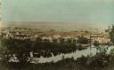
| Description: | Bird's-eye view of Jefferson on the Rock River. |
| Date: | 1880 |
|---|---|
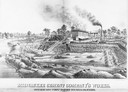
| Description: | Lithograph of the Milwaukee Cement Company's Works at 154 West Water Street in Milwaukee. |

| Date: | 1880 |
|---|---|
| Description: | Bird's-eye map of Waukesha, county seat of Waukesha County. |

| Date: | 1880 |
|---|---|
| Description: | Bird's-eye map of Neillsville, with inset. |
| Date: | 1880 |
|---|---|
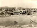
| Description: | View from high bank across the river of the Ingram and Pinkum sawmill (left), Ingram and Kennedy mill (right), later incorporated as the Empire Lumber Co. ... |

| Date: | 1880 |
|---|---|
| Description: | Clark's Saw and Planing Mill in the right foreground which is now the site of the electric plant. Behind Clark's is Plummers Mill where the Vocational Scho... |

| Date: | 1880 |
|---|---|
| Description: | Elevated view of Red Cedar (or Menomonie) River and the Knapp, Stout & Co., mills from the top of present day Meadow Hill Dr. looking Southeast. |
| Date: | 1880 |
|---|---|
| Description: | The sawmill of Gilbert E. Porter and Delos R. Moon was located on the Chippewa River approximately three miles southwest of the city of Eau Claire. In 1873... |
| Date: | 1880 |
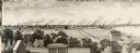
|---|---|
| Description: | Illustration of an elevated view over rooftops looking towards Oshkosh. There are chimneys along the horizon with smoke rising into the sky. A river is alo... |

| Date: | 1880 |
|---|---|
| Description: | Man in canoe close to shoreline with a bridge in the background. |
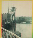
| Date: | 1880 |
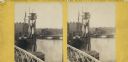
|---|---|
| Description: | Stereograph. Part of a bridge is visible in the lower left corner. Under the bridge is a floating pier with advertisements painted on its sides. Another br... |
| Date: | 1880 |
|---|---|
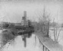
| Description: | View across river toward the malt house. In the background is the south side brewery of the same company. There are two steamboats, one large, one small. ... |
| Date: | 1880 |
|---|---|
| Description: | Stereograph. Part of a bridge is visible in the lower left corner. Under the bridge is a floating pier with advertisements painted on its sides. Another br... |

| Date: | 1880 |
|---|---|
| Description: | A hand-colored map of the Chippewa, Price, Taylor and the northern part of Clark counties, which shows the locations of farmhouses, schoolhouses, churches,... |

| Date: | 1880 |
|---|---|
| Description: | Map of Wisconsin including the eastern portions on Minnesota, Iowa, northern Illinois, and the western most portion of Michigan’s Upper Peninsula, showing ... |

| Date: | 1880 |
|---|---|
| Description: | A hand-colored, sectional map of Wisconsin showing the township grid, railroads, counties, towns, cities, villages, and the Menomonee, Oneida, Flambeau, an... |

| Date: | 1880 |
|---|---|
| Description: | This 1880 map of Clark County, Wisconsin, shows the township and range grid, towns, sections, cities and villages, railroads, roads, rivers and lakes, dams... |
If you didn't find the material you searched for, our Library Reference Staff can help.
Call our reference desk at 608-264-6535 or email us at: