 Filter: Categories of Wisconsin Historical Images
Filter: FULL_DATE of 1880
Filter: Subject of human settlements
Filter: Categories of Wisconsin Historical Images
Filter: FULL_DATE of 1880
Filter: Subject of human settlements
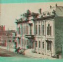
| Date: | 1880 |
|---|---|
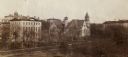
| Description: | Elevated view across Park Street of Chadbourne Hall on the University of Wisconsin-Madison campus. Adjacent buildings (to the hall) along Park Street are,... |
| Date: | 1880 |
|---|---|
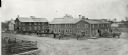
| Description: | Slightly elevated exterior view of T.G. Mandt Wagons & Carriages. Several of the men are standing near or leaning on one of the many carriages displayed ar... |
| Date: | 1880 |
|---|---|
| Description: | View down Langdon Street of building at base of Bascom Hill at the intersection with Park Street. This building stood from 1876-1884. A horse and carriage ... |
| Date: | 1880 |
|---|---|
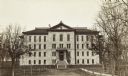
| Description: | A view of Sacred Heart College and the surrounding landscape. Each dormer window has a cross on its peak and the center of the building has a bell tower. |

| Date: | 1880 |
|---|---|
| Description: | View down sidewalk toward the Ceresco School. The building has tall arched windows, doorways, and round decorative brickwork. |
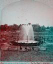
| Date: | 1880 |
|---|---|
| Description: | Stereograph of the Artesian Well near the intersection of Wisconsin and Minnesota (later renamed Wacouta) Streets. The following is printed on the back of ... |
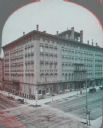
| Date: | 1880 |
|---|---|
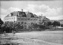
| Description: | Stereograph of elevated view of Newhall House which was destroyed by fire in 1883. |
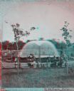
| Date: | 1880 |
|---|---|
| Description: | Stereograph of the Artesian Well near the intersection of Wisconsin and Minnesota (later renamed Wacouta) Streets. The following is printed on the backside... |
| Date: | 1880 |
|---|---|
| Description: | Stereograph; front of music hall along the road, with a horse and carriage team in front of the entrance. Buildings can also be seen in the left backgroun... |
| Date: | 1880 |
|---|---|
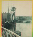
| Description: | Stereograph. Part of a bridge is visible in the lower left corner. Under the bridge is a floating pier with advertisements painted on its sides. Another br... |
| Date: | 1880 |
|---|---|
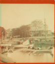
| Description: | Stereograph view of the Whiting House with its large harbor and boats. |
| Date: | 1880 |
|---|---|
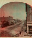
| Description: | Stereograph looking northeast from Case's Block. |
| Date: | 1880 |
|---|---|
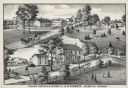
| Description: | An illustration depicting the cheese factory and dry goods store of J.G. Pickett at Pickett's Station. |
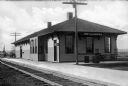
| Date: | 1880 |
|---|---|
| Description: | A view of the Weyauwega Train Depot building, platform, and railroad tracks. Signs on the building read, "Agency Western Express Co." and "Western Express ... |
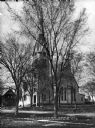
| Date: | 1880 |
|---|---|
| Description: | View of the facade and side of the Congregational Church, partially obscured by trees. The bell tower doubles as a clock tower. |

| Date: | 1880 |
|---|---|
| Description: | A hand-colored map of the Chippewa, Price, Taylor and the northern part of Clark counties, which shows the locations of farmhouses, schoolhouses, churches,... |

| Date: | 1880 |
|---|---|
| Description: | Map of Wisconsin including the eastern portions on Minnesota, Iowa, northern Illinois, and the western most portion of Michigan’s Upper Peninsula, showing ... |

| Date: | 1880 |
|---|---|
| Description: | A hand-colored, sectional map of Wisconsin showing the township grid, railroads, counties, towns, cities, villages, and the Menomonee, Oneida, Flambeau, an... |

| Date: | 1880 |
|---|---|
| Description: | This copy of an 1834 map in the American Fur Company's papers held by the New-York Historical Society shows an outline of Chequamegon Bay and Madeline Isla... |

| Date: | 1880 |
|---|---|
| Description: | This 1880 map of Clark County, Wisconsin, shows the township and range grid, towns, sections, cities and villages, railroads, roads, rivers and lakes, dams... |
If you didn't find the material you searched for, our Library Reference Staff can help.
Call our reference desk at 608-264-6535 or email us at: