 Filter: Categories of Wisconsin Historical Images
Filter: FULL_DATE of 1880
Filter: Subject of cities and towns
Filter: Categories of Wisconsin Historical Images
Filter: FULL_DATE of 1880
Filter: Subject of cities and towns

| Date: | 1880 |
|---|---|
| Description: | Stereograph of the Artesian Well near the intersection of Wisconsin and Minnesota (later renamed Wacouta) Streets. The following is printed on the back of ... |
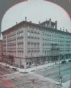
| Date: | 1880 |
|---|---|
| Description: | Stereograph of elevated view of Newhall House which was destroyed by fire in 1883. |
| Date: | 1880 |
|---|---|
| Description: | Stereograph of the Artesian Well near the intersection of Wisconsin and Minnesota (later renamed Wacouta) Streets. The following is printed on the backside... |
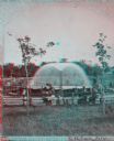
| Date: | 1880 |
|---|---|
| Description: | Stereograph; front of music hall along the road, with a horse and carriage team in front of the entrance. Buildings can also be seen in the left backgroun... |
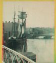
| Date: | 1880 |
|---|---|
| Description: | Stereograph. Part of a bridge is visible in the lower left corner. Under the bridge is a floating pier with advertisements painted on its sides. Another br... |

| Date: | 1880 |
|---|---|
| Description: | Stereograph view of the Whiting House with its large harbor and boats. |
| Date: | 1880 |
|---|---|
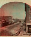
| Description: | Stereograph looking northeast from Case's Block. |
| Date: | 1880 |
|---|---|
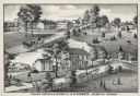
| Description: | An illustration depicting the cheese factory and dry goods store of J.G. Pickett at Pickett's Station. |
| Date: | 1880 |
|---|---|
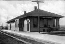
| Description: | A view of the Weyauwega Train Depot building, platform, and railroad tracks. Signs on the building read, "Agency Western Express Co." and "Western Express ... |

| Date: | 1880 |
|---|---|
| Description: | View of the facade and side of the Congregational Church, partially obscured by trees. The bell tower doubles as a clock tower. |

| Date: | 1880 |
|---|---|
| Description: | A hand-colored map of the Chippewa, Price, Taylor and the northern part of Clark counties, which shows the locations of farmhouses, schoolhouses, churches,... |

| Date: | 1880 |
|---|---|
| Description: | Map of Wisconsin including the eastern portions on Minnesota, Iowa, northern Illinois, and the western most portion of Michigan’s Upper Peninsula, showing ... |

| Date: | 1880 |
|---|---|
| Description: | A hand-colored, sectional map of Wisconsin showing the township grid, railroads, counties, towns, cities, villages, and the Menomonee, Oneida, Flambeau, an... |

| Date: | 1880 |
|---|---|
| Description: | This copy of an 1834 map in the American Fur Company's papers held by the New-York Historical Society shows an outline of Chequamegon Bay and Madeline Isla... |

| Date: | 1880 |
|---|---|
| Description: | This 1880 map of Clark County, Wisconsin, shows the township and range grid, towns, sections, cities and villages, railroads, roads, rivers and lakes, dams... |

| Date: | 1880 |
|---|---|
| Description: | Map created from original drawing and surveys taken by Silas Chapman. Bottom right corner features a reference key. There is a street guide on the left sid... |

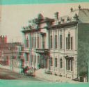
| Date: | 1880 |
|---|---|
| Description: | An exterior view of the Park Hotel, at the corner of Main and Carroll Streets. Children and adults are standing on the street corner on the left. A large g... |
| Date: | 1880 |
|---|---|
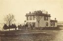
| Description: | View across lawn of the residence of Lucius Fairchild, in Madison. A woman is standing outdoors near the entrance. A fence surrounds the yard of the house,... |

| Date: | 1880 |
|---|---|
| Description: | This map of La Crosse shows the Chicago, Milwaukee and St. Paul Railroad, the Southern Minnesota Railroad and the Chicago, Dubuque and Minnesota Railroad, ... |

| Date: | 1880 |
|---|---|
| Description: | This map of the southern part of La Crosse is pen on cloth and shows proposed streets crossing the lands of Jane Usher and the Green Bay, Winona and St. Pa... |
If you didn't find the material you searched for, our Library Reference Staff can help.
Call our reference desk at 608-264-6535 or email us at: