Filter: Categories of Wisconsin Historical Images
Filter: FULL_DATE of 1879
Filter: Type of Map or Atlas
Filter: Subject of land
Filter: Categories of Wisconsin Historical Images
Filter: FULL_DATE of 1879
Filter: Type of Map or Atlas
Filter: Subject of land

| Date: | 1879 |
|---|---|
| Description: | Bird's-eye map of Lake Mills. |

| Date: | 1879 |
|---|---|
| Description: | Bird's-eye map of Two Rivers. |

| Date: | 1879 |
|---|---|
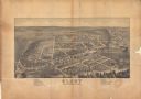
| Description: | Bird's-eye view of Viroqua, county seat of Vernon County. |

| Date: | 1879 |
|---|---|
| Description: | This map is a bird's-eye view of Wausau, the County Seat of Marathon County. The map features an index of points of interest. |

| Date: | 1879 |
|---|---|
| Description: | A map of Wisconsin as well as the southeastern most portions of Minnesota and Iowa and the Upper Peninsula of Michigan showing the township grids, railways... |

| Date: | 1879 |
|---|---|
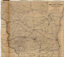
| Description: | A map of Wisconsin showing counties, county seats, cities over 3,000 inhabitants, Lake Michigan steamship routes, railroads completed and projected, rivers... |

| Date: | 1879 |
|---|---|
| Description: | A map of Jackson County, Wisconsin, shows the township and section survey, landownership, towns, villages, buildings, roads, railroads, county land, and st... |

| Date: | 1879 |
|---|---|
| Description: | This bird’s-eye-view map is a photostat copy of the orginal and is indexed for points of interest. Streets are labeled as well as the Barbaoo River. |
| Date: | 1879 |
|---|---|
| Description: | This map shows names of triangulation stations, railroads, counties, rivers, and lakes. The Mississippi River, Lake Winnebago, and Lake Michigan are labele... |
If you didn't find the material you searched for, our Library Reference Staff can help.
Call our reference desk at 608-264-6535 or email us at: