 Filter: Categories of Wisconsin Historical Images
Filter: FULL_DATE of 1877
Filter: Subject of transportation
Filter: Subject of human settlements
Filter: Categories of Wisconsin Historical Images
Filter: FULL_DATE of 1877
Filter: Subject of transportation
Filter: Subject of human settlements
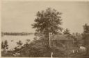
| Date: | 1877 |
|---|---|
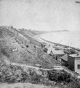
| Description: | View of bluffs and buildings on the shore of Lake Michigan. |

| Date: | 1877 |
|---|---|
| Description: | Bird's-eye map of Janesville on the Rock River. |
| Date: | 1877 |
|---|---|
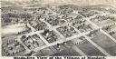
| Description: | Bird's-eye map of Mondovi. |
| Date: | 1877 |
|---|---|
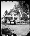
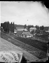
| Description: | View of Dr. Blake's (probably Samuel M.) house in Lodi or Prairie du Sac with a white picket fence in front of it. A man is standing in the grass in front ... |
| Date: | 1877 |
|---|---|
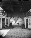
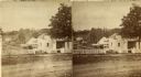
| Description: | View towards men and women sitting and standing, beneath the lower deck of a suspension bridge (train uses upper deck). There are two booths (for tolls or ... |
| Date: | 1877 |
|---|---|
| Description: | A view from the roof across an unpaved road towards a building across the street from A.L. Dahl's photography studio. The two-story storefront is a general... |
| Date: | 1877 |
|---|---|
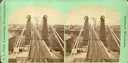
| Description: | "Top view of Suspension Bridge," from the series "Niagara Falls and Suspension Bridge" as noted in his 1877 "Catalogue of Stereoscopic Views." |
| Date: | 1877 |
|---|---|
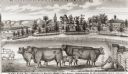
| Description: | View of cattle, sheep, and pigs in a pasture on a farm. Two houses are in the distance, and a horse-drawn carriage is moving along the road on the left. Ca... |
| Date: | 1877 |
|---|---|
| Description: | Stereograph view of Glenn's mineral spring. |
| Date: | 1877 |
|---|---|
| Description: | Photograph of a painting of the exterior of the Eben Peck cabin by Mrs. E.E. Bailey. The location of this original painting is unknown. |

| Date: | 1877 |
|---|---|
| Description: | Map of northern Wisconsin showing the lands owned by Cornell University (shaded portions) in 1877. The map depicts the lakes, river systems, towns, and th... |
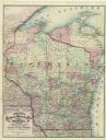
| Date: | 1877 |
|---|---|
| Description: | A hand-colored map of Wisconsin showing counties, township gridlines, river systems, and railroad routes throughout the state. The map also includes porti... |

| Date: | 1877 |
|---|---|
| Description: | A map of the triangulation and reconnaissance along the southwest corner of Wisconsin. The map shows the river systems, railroads, cities, and villages tha... |

| Date: | 1877 |
|---|---|
| Description: | A map of Monroe County, Wisconsin that shows the townships and landownership and acreage wagon roads, railroads, streams, schools, and houses. Also include... |

| Date: | 1877 |
|---|---|
| Description: | This 1877 map of Sauk County, Wisconsin, shows the township and range grid, sections, towns, cities and villages, land ownership and acreages, wagon roads,... |

| Date: | 1877 |
|---|---|
| Description: | This 1877 map of Trempealeau County, Wisconsin, shows the township and range grid, sections, towns, cities and villages, land ownership and acreages, roads... |

| Date: | 1877 |
|---|---|
| Description: | Shows land ownership by name, churches, schools, farm houses, wagon roads, railroads. Includes directory of businesses for Columbus, Portage, Doylestown, W... |

| Date: | 1877 |
|---|---|
| Description: | Two maps on one page, removed from an atlas. The first map shows Wisconsin and the upper peninsula of Michigan counties and townships while the second map ... |

| Date: | 1877 |
|---|---|
| Description: | Relief shown by hachures. Shows land ownership by name, wards, railroads, mills, dams, city limits, Chippewa River, and Half Moon Lake. Includes index of m... |

| Date: | 1877 |
|---|---|
| Description: | Relief shown by hachures. Shows land ownership by name, wards, railroads, mills, dams, city limits, Chippewa River, and Half Moon Lake. Includes index of m... |
If you didn't find the material you searched for, our Library Reference Staff can help.
Call our reference desk at 608-264-6535 or email us at: