 Filter: Categories of Wisconsin Historical Images
Filter: FULL_DATE of 1876
Filter: Subject of superior, lake
Filter: Categories of Wisconsin Historical Images
Filter: FULL_DATE of 1876
Filter: Subject of superior, lake
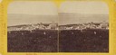
| Date: | 1876 |
|---|---|
| Description: | Stereograph view of Lake Superior scenery and downtown area. |
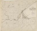
| Date: | 1876 |
|---|---|
| Description: | Map of the area around the head of Lake Superior, including the cities of Superior and Duluth. |

| Date: | 1876 |
|---|---|
| Description: | A map of Wisconsin and the western portion of Michigan’s Upper Peninsula showing the township grid, counties, towns, river systems, and lakes. The borders ... |

| Date: | 1876 |
|---|---|
| Description: | This map shows eastern Wisconsin, Lake Michigan, western Michigan, northeastern Illinois, and the southern part of Lake Superior. A note is included that r... |
| Date: | 1876 |
|---|---|
| Description: | This map shows mileages between rivers, lakes, and portages in Northern Wisconsin. Lake Superior is visible at the top of the map. Original caption reads, ... |
If you didn't find the material you searched for, our Library Reference Staff can help.
Call our reference desk at 608-264-6535 or email us at: