 Filter: Categories of Wisconsin Historical Images
Filter: FULL_DATE of 1876
Filter: Subject of rivers
Filter: Categories of Wisconsin Historical Images
Filter: FULL_DATE of 1876
Filter: Subject of rivers
| Date: | 1876 |
|---|---|
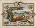
| Description: | Color chromolithograph illustration advertising poster for the Marsh Harvester, produced by Gammon and Deering Company. Printed by Charles Shober & Co., Ch... |

| Date: | 1876 |
|---|---|
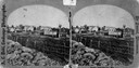
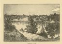
| Description: | Bird's-eye view of Black Earth. |
| Date: | 1876 |
|---|---|
| Description: | View, from the north bank of the Wisconsin River, of the 1899-foot railroad bridge in Merrimac. Two women and a man are sitting on the riverbank in the for... |
| Date: | 1876 |
|---|---|
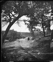
| Description: | Probably one of the "Three different views of the village of Argyle, Wis." mentioned in Dahl's 1877 "Catalogue of Stereoscopic Views." A view of the town a... |
| Date: | 1876 |
|---|---|
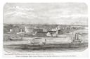
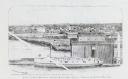
| Description: | Elevated view of Fort Howard taken from Elmore and Kelly's Elevator with the dam and river. A tugboat is in the river above the dam. Caption reads: "View o... |

| Date: | 1876 |
|---|---|
| Description: | Elevated view showing Elmore and Kelly's Elevator with a boat, train, and the buildings at Fort Howard. Fort Howard was incorporated into Green Bay. Captio... |
| Date: | 1876 |
|---|---|
| Description: | View looking southeast over river from Elmore and Kelly's Elevator. |

| Date: | 1876 |
|---|---|
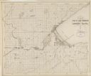
| Description: | Made from U.S. Surveys and from minutes furnished by Jos. S. Buck and Dr. C. Chase. Scale 20 CHs to an inch. |
| Date: | 1876 |
|---|---|
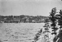
| Description: | Distant view of Neshotah Mission. River with boaters, two people standing on riverbank, mission on hill in background. |
| Date: | 1876 |
|---|---|
| Description: | Log jam on a high-water river, probably the Ice Gorge of 1876. |
| Date: | 1876 |
|---|---|
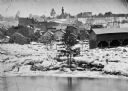
| Description: | Town with logs overflowing the river into yards, probably the Ice Gorge of 1876. |
| Date: | 1876 |
|---|---|
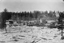
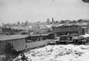
| Description: | Town and business district, showing the early covered bridge across from the tail race of the powerhouse, with logs overflowing the river into yards, proba... |
| Date: | 1876 |
|---|---|
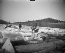
| Description: | Logs piled on the shore of town, possibly due to Ice Gorge of 1876. |
| Date: | 1876 |
|---|---|
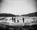
| Description: | Three men and a dog are standing on thick chunks of ice looking over logs on an icy river. |
| Date: | 1876 |
|---|---|
| Description: | Three men and a dog standing on ice floes and looking over logs on an icy river. |
| Date: | 1876 |
|---|---|
| Description: | Map of the area around the head of Lake Superior, including the cities of Superior and Duluth. |
| Date: | 1876 |
|---|---|
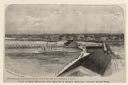
| Description: | Drawing of a ship being loaded by Elmore & Kelly's Elevator on Fort Howard River looking north. A town and a train are in the background. |

| Date: | 1876 |
|---|---|
| Description: | A map of Wisconsin and the western portion of Michigan’s Upper Peninsula showing the township grid, counties, towns, river systems, and lakes. The borders ... |
| Date: | 1876 |
|---|---|
| Description: | This color-coded map of the geology of southeastern Wisconsin shows the township grid, counties, towns, cities and villages, rivers, lakes, and railroads. ... |

| Date: | 1876 |
|---|---|
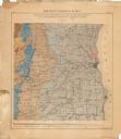
| Description: | This 1876 map of Saint Croix County, Wisconsin, shows the township and range grid, sections, towns, cities and villages, land ownership and acreages, wagon... |
If you didn't find the material you searched for, our Library Reference Staff can help.
Call our reference desk at 608-264-6535 or email us at: