 Filter: Categories of Wisconsin Historical Images
Filter: FULL_DATE of 1876
Filter: Subject of cities and towns
Filter: Subject of intellectual life
Filter: Categories of Wisconsin Historical Images
Filter: FULL_DATE of 1876
Filter: Subject of cities and towns
Filter: Subject of intellectual life

| Date: | 1876 |
|---|---|
| Description: | Bird's-eye view of Black Earth. |

| Date: | 1876 |
|---|---|
| Description: | Bird's-eye view of Middleton with an inset of a school house. |
| Date: | 1876 |
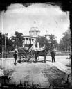
|---|---|
| Description: | Issued as a stereograph on green mount entitled "The Artist." Two men stand by a wagon on which is written "A.L. Dahl Landscape Photographer." The flag on... |
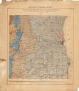
| Date: | 1876 |
|---|---|
| Description: | This color-coded map of the geology of southeastern Wisconsin shows the township grid, counties, towns, cities and villages, rivers, lakes, and railroads. ... |
If you didn't find the material you searched for, our Library Reference Staff can help.
Call our reference desk at 608-264-6535 or email us at:
