 Filter: Categories of Wisconsin Historical Images
Filter: FULL_DATE of 1876
Filter: Subject of cities and towns
Filter: Community of Milwaukee
Filter: Categories of Wisconsin Historical Images
Filter: FULL_DATE of 1876
Filter: Subject of cities and towns
Filter: Community of Milwaukee
| Date: | 1876 |
|---|---|
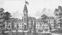
| Description: | Illustration of southwest view of the National Home For Disabled Volunteer Soldiers. The institution's name changed from National Asylum For Disabled Volun... |

| Date: | 1876 |
|---|---|
| Description: | Made from U.S. Surveys and from minutes furnished by Jos. S. Buck and Dr. C. Chase. Scale 20 CHs to an inch. |

| Date: | 1876 |
|---|---|
| Description: | Map of home and land, with the roads, lakes, railroad, and buildings. |
| Date: | 1876 |
|---|---|
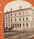
| Description: | Stereograph. Building also housed the Custom House. Corner of Milwaukee and Wisconisn Streets. |
If you didn't find the material you searched for, our Library Reference Staff can help.
Call our reference desk at 608-264-6535 or email us at:

