 Filter: Categories of Wisconsin Historical Images
Filter: FULL_DATE of 1876
Filter: Subject of cities and towns
Filter: Creator Name of Unknown
Filter: Categories of Wisconsin Historical Images
Filter: FULL_DATE of 1876
Filter: Subject of cities and towns
Filter: Creator Name of Unknown

| Date: | 1876 |
|---|---|
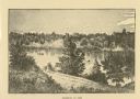
| Description: | Bird's-eye view of Black Earth. |

| Date: | 1876 |
|---|---|
| Description: | Bird's-eye view of Middleton with an inset of a school house. |
| Date: | 1876 |
|---|---|
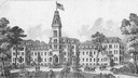
| Description: | Illustration of southwest view of the National Home For Disabled Volunteer Soldiers. The institution's name changed from National Asylum For Disabled Volun... |
| Date: | 1876 |
|---|---|
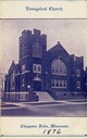
| Description: | Front entrance to the Evangelical Church, founded in approximately 1876. |
| Date: | 1876 |
|---|---|
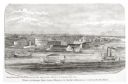
| Description: | View looking southeast over river from Elmore and Kelly's Elevator. |
| Date: | 1876 |
|---|---|
| Description: | Distant view of Neshotah Mission. River with boaters, two people standing on riverbank, mission on hill in background. |

| Date: | 1876 |
|---|---|
| Description: | Map shows townships and sections, landownership and acreages, roads, railroads, post offices, and farms. Sections appear in pink, yellow, and blue. On the ... |

| Date: | 1876 |
|---|---|
| Description: | This map is of the towns of Neenah and Menasha and shows existing and proposed canals. Water depths shown by soundings. Little Butte des Morts Lake, Doty I... |

| Date: | 1876 |
|---|---|
| Description: | This map is ink on tracing cloth and shows the Black River, French Slough, Little French Slough, the southern portion of North La Crosse, the Milwaukee & S... |
If you didn't find the material you searched for, our Library Reference Staff can help.
Call our reference desk at 608-264-6535 or email us at: