 Filter: Categories of Wisconsin Historical Images
Filter: FULL_DATE of 1876
Filter: Subject of bridges
Filter: Categories of Wisconsin Historical Images
Filter: FULL_DATE of 1876
Filter: Subject of bridges

| Date: | 1876 |
|---|---|
| Description: | View of a farmstead with fences, haystacks and a wooden outbuilding. Two men are posing on top of McCord Rock, one of them saluting with his hat. Another ... |
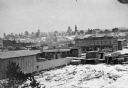
| Date: | 1876 |
|---|---|
| Description: | Probably one of the "Three different views of the village of Argyle, Wis." mentioned in Dahl's 1877 "Catalogue of Stereoscopic Views." A view of the town a... |
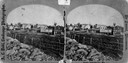
| Date: | 1876 |
|---|---|
| Description: | Town and business district, showing the early covered bridge across from the tail race of the powerhouse, with logs overflowing the river into yards, proba... |

| Date: | 1876 |
|---|---|
| Description: | This map is ink on tracing cloth and shows the Black River, French Slough, Little French Slough, the southern portion of North La Crosse, the Milwaukee & S... |
If you didn't find the material you searched for, our Library Reference Staff can help.
Call our reference desk at 608-264-6535 or email us at:
