 Filter: Categories of Wisconsin Historical Images
Filter: FULL_DATE of 1876
Filter: Subject of architecture
Filter: Categories of Wisconsin Historical Images
Filter: FULL_DATE of 1876
Filter: Subject of architecture

| Date: | 1876 |
|---|---|
| Description: | Map shows landownership and acreages, roads and railroads, and some buildings. Includes illustrations of local buildings, business directories, and tables ... |

| Date: | 1876 |
|---|---|
| Description: | Map shows townships and sections, landownership and acreages, roads, railroads, post offices, and farms. Sections appear in pink, yellow, and blue. On the ... |
| Date: | 1876 |
|---|---|
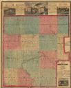
| Description: | Map shows townships and sections, landownership and acreages, roads, railroads, and selected rural buildings. Sections are shown in green, blue, and red. T... |
| Date: | 1876 |
|---|---|
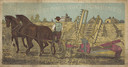
| Description: | Advertising card with a color illustration of a man using the Johnston Light Combine in a field with two horses. The back of the card describes the agricul... |
| Date: | 1876 |
|---|---|
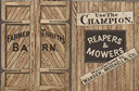
| Description: | Front and back cover of brochure for Champion Reapers & Mowers. Front cover features flaps illustrated as barn doors that open up to reveal the brochure. |

| Date: | 1876 |
|---|---|
| Description: | A hand-colored map on six sheets, this map of Juneau County indicates the locations of townships and sections, landowners and acreages, roads, wagon roads,... |
If you didn't find the material you searched for, our Library Reference Staff can help.
Call our reference desk at 608-264-6535 or email us at: