 Filter: Categories of Wisconsin Historical Images
Filter: FULL_DATE of 1875
Filter: Subject of cities and towns
Filter: Categories of Wisconsin Historical Images
Filter: FULL_DATE of 1875
Filter: Subject of cities and towns

| Date: | 1875 |
|---|---|
| Description: | Corner of Mitchell and S. 5th Street. The twin towered building seen today was completed in 1873. |

| Date: | 1875 |
|---|---|
| Description: | Exterior of the front and east side of the Bennett Studio when it was new, showing the skylight and the revolving print house. There is a large windmill be... |

| Date: | 1875 |
|---|---|
| Description: | Front and west side of Bennett Studio. There is a windmill behind the building. |
| Date: | 1875 |
|---|---|
| Description: | "Iron Bridge across Mississippi" photographed during "The Norwegian Lutheran Synod held at Minneapolis, Minn., 1875," as described in Dahl's 1877 "Catalogu... |
| Date: | 1875 |
|---|---|
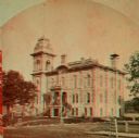
| Description: | Stereograph of the courthouse before remodeling during the spring or summer. |

| Date: | 1875 |
|---|---|
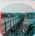
| Description: | Stereograph of Wisconsin Street seen from Spring Street. The building on the left nearest the bridge was the Chicago, Milwaukee & St. Paul Railway's downto... |
| Date: | 1875 |
|---|---|
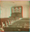
| Description: | Stereograph of the organ inside of the Presbyterian church. This site is now occupied by the Masonic Temple. |
| Date: | 1875 |
|---|---|
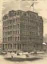
| Description: | Newspaper engraving of the building at Randolph and Dearborn Streets that served as the McCormick General Office from 1879 to 1885. An American flag flies ... |

| Date: | 1875 |
|---|---|
| Description: | This manuscript map shows the limits of the land grants made to railroads in northwestern Wisconsin along the corridor between Portage and Hudson, along th... |

| Date: | 1875 |
|---|---|
| Description: | This hand-colored map of Wisconsin and the western portion of Michigan's Upper Peninsula depicts the township survey grid and identifies counties, named to... |
| Date: | 1875 |
|---|---|
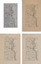
| Description: | A series of four, ink on tracing cloth maps of Milwaukee County, Wisconsin that show the topography, the Milwaukee and Menomonee rivers, and railroad of th... |

| Date: | 1875 |
|---|---|
| Description: | This manuscript map by Increase Lapham, drawn in the last year of his life, shows landownership, roads and railroads, springs, and boat houses around Ocono... |

| Date: | 1875 |
|---|---|
| Description: | This map, from G.K. Warren's 1876 Report on the transportation route along the Wisconsin and Fox Rivers in the State of Wisconsin between the Mississippi R... |

| Date: | 1875 |
|---|---|
| Description: | One of a set of maps from G.K. Warren's 1876 Report on the transportation route along the Wisconsin and Fox rivers in the State of Wisconsin between the Mi... |

| Date: | 1875 |
|---|---|
| Description: | Shows land ownership by name, local streets, buildings, cemeteries, Chippewa River, and Half Moon Lake. Includes 1 inset map of Eau Claire. Also includes c... |

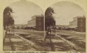
| Date: | 1875 |
|---|---|
| Description: | Elevated view over De Pere. In the foreground is the De Pere News Office and Post Office building. Behind it people are walking on the bridge over the Fox ... |
| Date: | 1875 |
|---|---|
| Description: | Stereograph view of Black Hawk Avenue. |

| Date: | 1875 |
|---|---|
| Description: | View over town looking east from the railroad station. |

| Date: | 1875 |
|---|---|
| Description: | This map shows land ownership by name, plat of town, local streets, fairgrounds, part of White and Fox Rivers. The map includes illustrations of buildings ... |
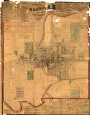
| Date: | 1875 |
|---|---|
| Description: | This map shows plat of the town, land ownership by name, wards, local streets, railroads, and part of Fox River. The map also includes a directory and adve... |
If you didn't find the material you searched for, our Library Reference Staff can help.
Call our reference desk at 608-264-6535 or email us at: