Filter: Categories of Wisconsin Historical Images
Filter: FULL_DATE of 1875
Filter: Subject of bird's-eye views
Filter: Categories of Wisconsin Historical Images
Filter: FULL_DATE of 1875
Filter: Subject of bird's-eye views

| Date: | 1875 |
|---|---|
| Description: | Bird's-eye map of Black River Falls, looking southwest. |
| Date: | 1875 |
|---|---|
| Description: | Bird's-eye map of Dodgeville, looking east, with insets of the high school and county courthouse. |
| Date: | 1875 |
|---|---|
| Description: | Bird's-eye map of Lancaster, with inset of Monument for the Soldiers of Grant County. |

| Date: | 1875 |
|---|---|
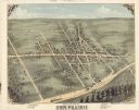
| Description: | Bird's-eye map of Mazomanie. |

| Date: | 1875 |
|---|---|
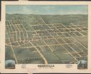
| Description: | Bird's-eye map of Menomonie, with an inset of the County Court House. Spelled Menomonee on map. |

| Date: | 1875 |
|---|---|
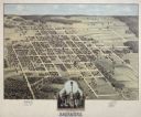
| Description: | Bird's-eye map of Platteville. |

| Date: | 1875 |
|---|---|
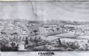
| Description: | Bird's-eye map after a fire destroyed a large area of the town. In memory of the Great Conflagration on April 28th, 1875. Taken from the North-Side. |

| Date: | 1875 |
|---|---|
| Description: | Bird's-eye map of Richland Center. |
If you didn't find the material you searched for, our Library Reference Staff can help.
Call our reference desk at 608-264-6535 or email us at: