 Filter: Categories of Wisconsin Historical Images
Filter: FULL_DATE of 1875
Filter: Creator Name of Unknown
Filter: Subject of water
Filter: Categories of Wisconsin Historical Images
Filter: FULL_DATE of 1875
Filter: Creator Name of Unknown
Filter: Subject of water

| Date: | 1875 |
|---|---|
| Description: | Aerial view of Alma along Mississippi River, with bluffs along the horizon. |

| Date: | 1875 |
|---|---|
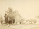
| Description: | An artist's depiction of an elevated view of the first State Fish Hatchery (aka Nevin Fish Hatchery, 3911 Fish Hatchery Road). |

| Date: | 1875 |
|---|---|
| Description: | The harbor piers and the entrance to the Sturgeon Bay ship canal. Men are standing on the shoreline. |
| Date: | 1875 |
|---|---|
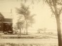
| Description: | Exterior view of the Giles house, residence of Hiram H. Giles, state legislator and social welfare authority. |
| Date: | 1875 |
|---|---|
| Description: | The Giles house, residence of Hiram H. Giles, state legislator and social welfare authority. |

| Date: | 1875 |
|---|---|
| Description: | Exterior view of the Giles house, residence of Hiram H. Giles, state legislator and social welfare authority. |
| Date: | 1875 |
|---|---|
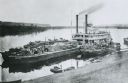
| Description: | View down hill towards "Diamond Jo" steamboat docked on the shoreline of the Mississippi River while goods are being loaded onto the steamboat. |
| Date: | 1875 |
|---|---|
| Description: | A full circle panorama as it would be seen from the top of the Wisconsin State Capitol. This painting was based on photographs perhaps taken by Edward Niel... |

| Date: | 1875 |
|---|---|
| Description: | A hand-drawn and colored map of Wisconsin showing the railroad routs and railroad land grants La Cross and Milwaukee Railroad, St. Croix and Tomah Railroad... |

| Date: | 1875 |
|---|---|
| Description: | Handwritten note on back identifies this elevated view as the west side of Broadway from National Bank, looking south. The Fox River is in the background o... |

| Date: | 1875 |
|---|---|
| Description: | The City of Fort Howard, Brown County, Wisconsin. Compiled from the records and drawn by F.E. Predergast, of De Pere. |

| Date: | 1875 |
|---|---|
| Description: | Elevated view of several buildings, with bridge and railroad tracks, and the Fox River. In the foreground on the right is the Commercial House, with three ... |
If you didn't find the material you searched for, our Library Reference Staff can help.
Call our reference desk at 608-264-6535 or email us at:
