 Filter: Categories of Wisconsin Historical Images
Filter: FULL_DATE of 1874
Filter: Subject of streets
Filter: Categories of Wisconsin Historical Images
Filter: FULL_DATE of 1874
Filter: Subject of streets

| Date: | 1874 |
|---|---|
| Description: | Bird's-eye map of Chippewa Falls. |

| Date: | 1874 |
|---|---|
| Description: | Bird's-eye map of Racine, with an inset of Racine College. |

| Date: | 1874 |
|---|---|
| Description: | Bird's-eye view of Waukesha, looking southwest, with insets of State Industrial School, Court House, and Fountain Spring House. |
| Date: | 1874 |
|---|---|
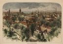
| Description: | Bird's-eye view of Milwaukee looking southwest toward the county courthouse under construction in the public square west of St. John's Cathedral. |
| Date: | 1874 |
|---|---|
| Description: | Elevated view towards the northwest across West Washington Avenue of the Congregationalist Church. Main Hall (now Bascom Hall) of the University of Wiscons... |

| Date: | 1874 |
|---|---|
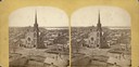
| Description: | A view from the 300 Block of State Street, looking east toward the Wisconsin State Capitol. |

| Date: | 1874 |
|---|---|
| Description: | Southeast Gate of Capitol Park. Four stone columns stand along the sidewalk, with statues on top of the two columns in the center, and two columns with str... |
| Date: | 1874 |
|---|---|
| Description: | View from Capital Park towards the United States Court House. There is a stone gateway with iron statues and an iron fence along the sidewalk. The elaborat... |

| Date: | 1874 |
|---|---|
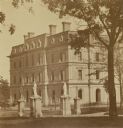
| Description: | Residence of the Honorable David Atwood on the corner of West Doty Street and Monona Avenue (now Martin Luther King, Jr. Blvd.). People are posing on the p... |

| Date: | 1874 |
|---|---|
| Description: | View of the University of Wisconsin-Madison from the Wisconsin State Capitol. |

| Date: | 1874 |
|---|---|
| Description: | Elevated view of Main Street from Pinckney Street. A sign on the top of the building reads: "Solders' Record Office." |

| Date: | 1874 |
|---|---|
| Description: | Includes index to key buildings. Shows local streets, railroads, fairgrounds, mills, schools, churches, and part of Lake Winnebago. Streets running west to... |

| Date: | 1874 |
|---|---|
| Description: | This map of La Crosse is accompanied by other plats of subdivision of the city. The relief is shown by hachures. The additions include: Rudolf Gripps Addit... |

| Date: | 1874 |
|---|---|
| Description: | This map has relief shown by hachures and includes 7 inset maps of additions and subdivisions with varying scales. Also includes index of additions and loc... |

| Date: | 1874 |
|---|---|
| Description: | This map shows streets, buildings, railroads, the Fox River, the East River, and part of Green Bay. |

| Date: | 1874 |
|---|---|
| Description: | This map shows piers, streets, the Manitowoc River and shore lines of 1856, 1869, 1873 and 1874. The top margin reads; "Soundings taken 1974." Written in i... |

| Date: | 1874 |
|---|---|
| Description: | Birds-eye view of Appleton Wisconsin. In the foreground are people fishing, strolling, and looking over the canal towards the Fox River. Streets and buildi... |
If you didn't find the material you searched for, our Library Reference Staff can help.
Call our reference desk at 608-264-6535 or email us at:

