 Filter: Categories of Wisconsin Historical Images
Filter: FULL_DATE of 1874
Filter: Subject of school buildings
Filter: Categories of Wisconsin Historical Images
Filter: FULL_DATE of 1874
Filter: Subject of school buildings

| Date: | 1874 |
|---|---|
| Description: | Bird's-eye view of Waukesha, looking southwest, with insets of State Industrial School, Court House, and Fountain Spring House. |

| Date: | 1874 |
|---|---|
| Description: | View of the University of Wisconsin-Madison from the Wisconsin State Capitol. |

| Date: | 1874 |
|---|---|
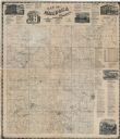
| Description: | This 1873 map covers the northern halves (Towns 11 and 12) of Washington and Ozaukee counties. Shown are the township and range grid, towns, sections, citi... |

| Date: | 1874 |
|---|---|
| Description: | Bird's-eye view map of Appleton, Wisconsin. Map reads: "NOTE.-Since the above cut was engraved, the Fox River Pulp & Paper Co.'s Mammoth Mills have been er... |
| Date: | 1874 |
|---|---|
| Description: | This map shows townships and sections, land ownership and acreages, churches, schools, cemeteries, roads, railroads, and projected railroads. The map inclu... |

| Date: | 1874 |
|---|---|
| Description: | Birds-eye view of Appleton Wisconsin. In the foreground are people fishing, strolling, and looking over the canal towards the Fox River. Streets and buildi... |
If you didn't find the material you searched for, our Library Reference Staff can help.
Call our reference desk at 608-264-6535 or email us at:
