 Filter: Categories of Wisconsin Historical Images
Filter: FULL_DATE of 1874
Filter: Subject of roads
Filter: Categories of Wisconsin Historical Images
Filter: FULL_DATE of 1874
Filter: Subject of roads

| Date: | 1874 |
|---|---|
| Description: | This map shows lakes, rivers, state, county, and town boundaries, as well as railroads completed, in progress, and contemplated. The map includes a color d... |
| Date: | 1874 |
|---|---|
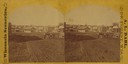
| Description: | View looking southwest down the 600 block of Williamson Street to the East Madison Passenger Depot of the Chicago & Northwestern Railroad. There are frame ... |

| Date: | 1874 |
|---|---|
| Description: | Bird's-eye map of Lodi, with inset of Public School. Includes index of churches and points of interest. |
| Date: | 1874 |
|---|---|
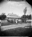
| Description: | Family and frame house of Lars David Reque. Two carriages and a family are posed in front of a picket fence. Behind them is a large frame house with carpen... |
| Date: | 1874 |
|---|---|
| Description: | Three boys sitting in front of a picket fence. Behind them are more people in the yard of an urban bracket style house that has a small front porch, parape... |
| Date: | 1874 |
|---|---|
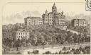
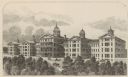
| Description: | State University (University of Wisconsin), Madison. |
| Date: | 1874 |
|---|---|
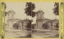
| Description: | Wisconsin State Hospital for the Insane (Mendota Mental Health Institute) near Madison. |
| Date: | 1874 |
|---|---|
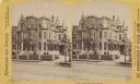
| Description: | Stereograph of Broadway in Milwaukee. Home has many peaks on the roof, and the drive to the entrance is on the right. |
| Date: | 1874 |
|---|---|
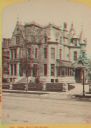
| Description: | Stereograph. Jackson Street. Tower missing the top two levels of later images. |

| Date: | 1874 |
|---|---|
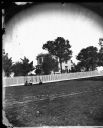
| Description: | Stereograph of elevated view looking northwest from Exposition Building. There is a church on a street corner on the left, and the Best Brewing Company in ... |
| Date: | 1874 |
|---|---|
| Description: | Stereograph of Broadway in Milwaukee. The mansion has many peaks on the roof, and the drive to the entrance is on the right. |

| Date: | 1874 |
|---|---|
| Description: | Stereograph of elevated view looking northwest from Exposition Building. There is a church on a street corner on the left, and the Best Brewing Company in ... |

| Date: | 1874 |
|---|---|
| Description: | This map of Wisconsin shows cities, counties, railroads already completed and railroads projected, and geological makeup of the land such as lakes. |

| Date: | 1874 |
|---|---|
| Description: | This 1873 map covers the northern halves (Towns 11 and 12) of Washington and Ozaukee counties. Shown are the township and range grid, towns, sections, citi... |

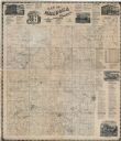
| Date: | 1874 |
|---|---|
| Description: | Map shows townships and sections, landownership and acreages, railroads, and roads. The map was compiled by the civil engineer and city surveyor agent H.I.... |

| Date: | 1874 |
|---|---|
| Description: | Bird's-eye view map of Appleton, Wisconsin. Map reads: "NOTE.-Since the above cut was engraved, the Fox River Pulp & Paper Co.'s Mammoth Mills have been er... |

| Date: | 1874 |
|---|---|
| Description: | This map shows townships and sections, post offices, roads, and railroads. The left margin reads: "For sale at Cushing Land Agency, St. Croix Falls, Wis. 4... |
| Date: | 1874 |
|---|---|
| Description: | This map shows townships and sections, land ownership and acreages, churches, schools, cemeteries, roads, railroads, and projected railroads. The map inclu... |
If you didn't find the material you searched for, our Library Reference Staff can help.
Call our reference desk at 608-264-6535 or email us at:
