 Filter: Categories of Wisconsin Historical Images
Filter: FULL_DATE of 1874
Filter: Subject of lakes
Filter: Categories of Wisconsin Historical Images
Filter: FULL_DATE of 1874
Filter: Subject of lakes

| Date: | 1874 |
|---|---|
| Description: | This map shows lakes, rivers, state, county, and town boundaries, as well as railroads completed, in progress, and contemplated. The map includes a color d... |
| Date: | 1874 |
|---|---|
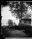
| Description: | Partial view of billiard hall and Lake Mendota from the Ole Bull Residence, 130 East Gilman Street. Two people on shore are pointing to a sailboat. Later, ... |

| Date: | 1874 |
|---|---|
| Description: | Ole Bull Residence Billiard Hall behind his house, 130 E. Gilman Street. Frame building with railing on side and latticework on bottom, with shutters and c... |

| Date: | 1874 |
|---|---|
| Description: | Distant view of the town from a hill with houses, garden plots, businesses and churches. |

| Date: | 1874 |
|---|---|
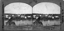
| Description: | Elevated view from hill of Clinton, now Rockdale. Three men are in the middle distance, looking east across Koshonong Creek towards a mill dam, bridge and ... |
| Date: | 1874 |
|---|---|
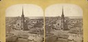
| Description: | Elevated view towards the northwest across West Washington Avenue of the Congregationalist Church. Main Hall (now Bascom Hall) of the University of Wiscons... |
| Date: | 1874 |
|---|---|
| Description: | View west from the Cliff House at Devil's Lake. |
| Date: | 1874 |
|---|---|
| Description: | A distant view of Clinton, now Rockdale, in Christiana Township looking across the millpond on Koshkonong Creek towards the town. |
| Date: | 1874 |
|---|---|
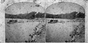
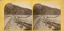
| Description: | A yellow mount stereograph of the railroad tracks skirting the edge of Devil's Lake, with several boats tied up alongside. From the stereograph series "The... |

| Date: | 1874 |
|---|---|
| Description: | View across Lake Mendota toward Bascom Hall from 2-16 Langdon Street. |

| Date: | 1874 |
|---|---|
| Description: | View towards Lake Monona (David Atwood House in foreground, Monona Avenue and Doty Street). |

| Date: | 1874 |
|---|---|
| Description: | View of the University of Wisconsin-Madison from the Wisconsin State Capitol. |
| Date: | 1874 |
|---|---|
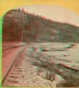
| Description: | A yellow mount stereograph of the railroad tracks skirting the edge of Devil's Lake, with several boats tied up alongside. From the stereograph series "The... |
| Date: | 1874 |
|---|---|
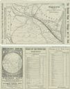
| Description: | A folded brochure with a map of the Chicago to Saint Paul rail line through Wisconsin by way of the Chicago & North-Western and West Wisconsin Railways. Th... |

| Date: | 1874 |
|---|---|
| Description: | A hand-colored, geological map of Wisconsin show the progress of the state geological survey in 1873 and 1874. Other elements displayed in the map include... |

| Date: | 1874 |
|---|---|
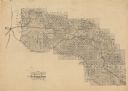
| Description: | This map shows lands in the vicinity of the railway route between St. Paul and Chicago, extending from Valley Junction (labelled Wisconsin Valley Junction ... |

| Date: | 1874 |
|---|---|
| Description: | This map of Wisconsin shows cities, counties, railroads already completed and railroads projected, and geological makeup of the land such as lakes. |

| Date: | 1874 |
|---|---|
| Description: | This hand-colored map shows the railroads "completed" "in progress" and "contemplated" rivers, counties, cities and villages, and named towns in the state,... |

| Date: | 1874 |
|---|---|
| Description: | This hand-colored map of Wisconsin and the western portion of Michigan's Upper Peninsula, shows the township grid, railroads completed and in progress, cou... |
| Date: | 1874 |
|---|---|
| Description: | Map of the lands in the vicinity of the West Wisconsin Railway route between St. Paul and Chicago, extending from St. Paul, Minnesota southeast to the Wisc... |
If you didn't find the material you searched for, our Library Reference Staff can help.
Call our reference desk at 608-264-6535 or email us at: