 Filter: Categories of Wisconsin Historical Images
Filter: FULL_DATE of 1874
Filter: Subject of cities and towns
Filter: Categories of Wisconsin Historical Images
Filter: FULL_DATE of 1874
Filter: Subject of cities and towns

| Date: | 1874 |
|---|---|
| Description: | This map shows lakes, rivers, state, county, and town boundaries, as well as railroads completed, in progress, and contemplated. The map includes a color d... |
| Date: | 1874 |
|---|---|
| Description: | View looking southwest down the 600 block of Williamson Street to the East Madison Passenger Depot of the Chicago & Northwestern Railroad. There are frame ... |

| Date: | 1874 |
|---|---|
| Description: | Bird's-eye map of Reedsburg, on the Baraboo River. |

| Date: | 1874 |
|---|---|
| Description: | Bird's-eye view of Beloit, with insets of Beloit College, Beloit High School, and Memorial Hall. |

| Date: | 1874 |
|---|---|
| Description: | Bird's-eye map of Chippewa Falls. |

| Date: | 1874 |
|---|---|
| Description: | Bird's-eye map of Grand Rapids. |

| Date: | 1874 |
|---|---|
| Description: | Bird's-eye map of Racine, with an inset of Racine College. |

| Date: | 1874 |
|---|---|
| Description: | Bird's-eye view of Waukesha, looking southwest, with insets of State Industrial School, Court House, and Fountain Spring House. |

| Date: | 1874 |
|---|---|
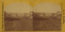
| Description: | Elevated view from hill of Clinton, now Rockdale. Three men are in the middle distance, looking east across Koshonong Creek towards a mill dam, bridge and ... |
| Date: | 1874 |
|---|---|
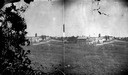
| Description: | View, from a distance, of Fulton Street in Edgerton. A church is in the distance. |
| Date: | 1874 |
|---|---|
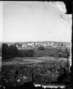
| Description: | View of New Glarus from a neighboring hill. A man, wearing a hat and suit, and five children, girls and boys, are posing along the fence in the foreground.... |
| Date: | 1874 |
|---|---|
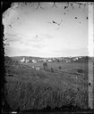
| Description: | View, from a distance, of New Glarus. A hill, trees and fences are in the foreground. |
| Date: | 1874 |
|---|---|
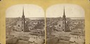
| Description: | Elevated view towards the northwest across West Washington Avenue of the Congregationalist Church. Main Hall (now Bascom Hall) of the University of Wiscons... |

| Date: | 1874 |
|---|---|
| Description: | Southeast Gate of Capitol Park. Four stone columns stand along the sidewalk, with statues on top of the two columns in the center, and two columns with str... |

| Date: | 1874 |
|---|---|
| Description: | Wisconsin State Capitol from the south gate. |

| Date: | 1874 |
|---|---|
| Description: | View towards Lake Monona (David Atwood House in foreground, Monona Avenue and Doty Street). |
| Date: | 1874 |
|---|---|
| Description: | View from Capital Park towards the United States Court House. There is a stone gateway with iron statues and an iron fence along the sidewalk. The elaborat... |

| Date: | 1874 |
|---|---|
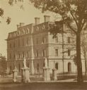
| Description: | Residence of the Honorable David Atwood on the corner of West Doty Street and Monona Avenue (now Martin Luther King, Jr. Blvd.). People are posing on the p... |
If you didn't find the material you searched for, our Library Reference Staff can help.
Call our reference desk at 608-264-6535 or email us at:

