Filter: Categories of Wisconsin Historical Images
Filter: FULL_DATE of 1874
Filter: Creator Name of Unknown
Filter: Subject of cities and towns
Filter: Categories of Wisconsin Historical Images
Filter: FULL_DATE of 1874
Filter: Creator Name of Unknown
Filter: Subject of cities and towns

| Date: | 1874 |
|---|---|
| Description: | Bird's-eye map of Chippewa Falls. |

| Date: | 1874 |
|---|---|
| Description: | Bird's-eye map of Lodi, with inset of Public School. Includes index of churches and points of interest. |
| Date: | 1874 |
|---|---|
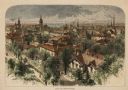
| Description: | Bird's-eye view of Milwaukee looking southwest toward the county courthouse under construction in the public square west of St. John's Cathedral. |
| Date: | 1874 |
|---|---|
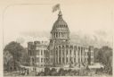
| Description: | State University (University of Wisconsin), Madison. |
| Date: | 1874 |
|---|---|
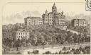
| Description: | Wisconsin State Hospital for the Insane (Mendota Mental Health Institute) near Madison. |

| Date: | 1874 |
|---|---|
| Description: | Map of New Diggings — inset map in bottom right corner of "Benton & New Diggings" map, on page 11 of "Atlas of Lafayette County Wisconsin," a collect... |
| Date: | 1874 |
|---|---|
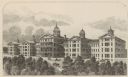
| Description: | The residence of John Crapser Coleman, as remodeled in 1870. A large house is in the middle of the image, with a drive leading up to the left of the house... |

| Date: | 1874 |
|---|---|
| Description: | This map shows townships and sections, post offices, roads, and railroads. The left margin reads: "For sale at Cushing Land Agency, St. Croix Falls, Wis. 4... |

| Date: | 1874 |
|---|---|
| Description: | This map shows piers, streets, the Manitowoc River and shore lines of 1856, 1869, 1873 and 1874. The top margin reads; "Soundings taken 1974." Written in i... |
If you didn't find the material you searched for, our Library Reference Staff can help.
Call our reference desk at 608-264-6535 or email us at: