Filter: Categories of Wisconsin Historical Images
Filter: FULL_DATE of 1873
Filter: Subject of water
Filter: Categories of Wisconsin Historical Images
Filter: FULL_DATE of 1873
Filter: Subject of water

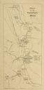
| Date: | 1873 |
|---|---|
| Description: | Map of the township of Windsor, from the "Atlas of Dane County." |

| Date: | 1873 |
|---|---|
| Description: | Newspaper reproduction of an etching of the Milwaukee River. |

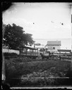
| Date: | 1873 |
|---|---|
| Description: | The harbor, showing the sidewheel packet, "Belle of La Crosse," and the sidewheel ferry "Alex McGregor." Other boats are also seen including two barges loa... |

| Date: | 1873 |
|---|---|
| Description: | Bird's-eye map of La Crosse from the Mississippi River. |
| Date: | 1873 |
|---|---|
| Description: | View from the foot of Carroll Street with the Angle Worm Station at Barnes boat landing on Lake Monona. Shows the Scutt II taken from the first succ... |
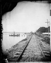
| Date: | 1873 |
|---|---|
| Description: | View down railroad tracks at Angle Worm Station alongside Lake Monona. The station's unusual name originated from a speech given by Captain Frank Barnes ev... |
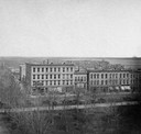
| Date: | 1873 |
|---|---|
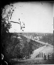
| Description: | Elevated view of South Pinckney Street from the Wisconsin State Capitol, with East Washington Avenue to the left and Lake Monona on the distant right. The ... |
| Date: | 1873 |
|---|---|
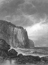
| Description: | Drawing of the entrance to Baptism Bay on Lake Superior. |
| Date: | 1873 |
|---|---|
| Description: | View, from the south bank of the Wisconsin River, looking towards Merrimac, Sauk County. People are standing on the 1899-foot railroad bridge, which runs ... |
| Date: | 1873 |
|---|---|
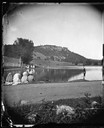
| Description: | View across lake towards fisherman casting before spectators. Gibraltar Rock, northwest of Lodi, Wisconsin, is in the distance. |
| Date: | 1873 |
|---|---|
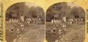
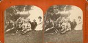
| Description: | Identified as " Lover's Retreat, Spring View." Group in field with stream on a picnic. Children are stepping on stones in foreground with U.S. flag, people... |
| Date: | 1873 |
|---|---|
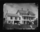
| Description: | Allen E. Adsit is in the left foreground in this photograph and his father, Stephen Adsit, is seated at right. Seen near the house are a wooden rain barrel... |

| Date: | 1873 |
|---|---|
| Description: | A Norwegian Sunday school picnic, perhaps held at Maple Bluff on Lake Mendota. The original stereograph is in the collection of the Norwegian-American Hist... |
| Date: | 1873 |
|---|---|
| Description: | A group of campers at McBride's Point at Maple Bluff on Lake Mendota. They are equipped with German exercise equipment (exercise pins, "kegels"), a horn (l... |
| Date: | 1873 |
|---|---|
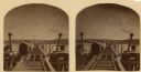
| Description: | Stereograph of John Lawler's pile-pontoon railway bridge over both channels of the Mississippi River at Prairie du Chien, and McGregor, Iowa. East draw, 39... |

| Date: | 1873 |
|---|---|
| Description: | Portion of Winnebago County map showing Lake Winneconne and the Wolf River. |

| Date: | 1873 |
|---|---|
| Description: | Color outline map of Dane County, Wisconsin. |
| Date: | 1873 |
|---|---|
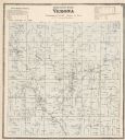
| Description: | A map of Verona Township from the Dane County Atlas. |
If you didn't find the material you searched for, our Library Reference Staff can help.
Call our reference desk at 608-264-6535 or email us at: