 Filter: Categories of Wisconsin Historical Images
Filter: FULL_DATE of 1873
Filter: Subject of michigan, lake
Filter: Categories of Wisconsin Historical Images
Filter: FULL_DATE of 1873
Filter: Subject of michigan, lake
| Date: | 1873 |
|---|---|
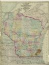
| Description: | A map of Wisconsin along with southeastern Minnesota and Iowa, northern Illinois and the Upper Peninsula of Michigan, showing the counties, county seats, v... |

| Date: | 1873 |
|---|---|
| Description: | A hand-colored map of Minnesota, Wisconsin, and Michigan shows the counties, cities, villages, rivers, lakes, railroads, and steamboat routes in these stat... |

| Date: | 1873 |
|---|---|
| Description: | Map of Wisconsin showing counties, county seats, cities with populations over 3,000, and congressional districts. The map also includes rivers, lakes, rail... |

| Date: | 1873 |
|---|---|
| Description: | This hand-colored map of Wisconsin depicts the township survey grid and identifies counties, named towns, cities and villages, rivers, lakes, railroads, an... |

| Date: | 1873 |
|---|---|
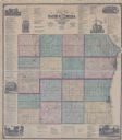
| Description: | This hand-colored map of Wisconsin shows the township grid, railroads and proposed railroads, counties, cities, villages, and post offices. Population tabl... |
| Date: | 1873 |
|---|---|
| Description: | This hand-colored map includes business directories, a statistical table, as well as illustrations of public, residential, and commercial properties. Commu... |
If you didn't find the material you searched for, our Library Reference Staff can help.
Call our reference desk at 608-264-6535 or email us at: