Filter: Categories of Wisconsin Historical Images
Filter: FULL_DATE of 1873
Filter: Subject of human settlements
Filter: Categories of Wisconsin Historical Images
Filter: FULL_DATE of 1873
Filter: Subject of human settlements

| Date: | 1873 |
|---|---|
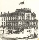
| Description: | Slightly elevated engraved view of the Walworth County Courthouse. In the foreground a man is riding a horse along the street. Pedestrians are on the groun... |
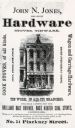
| Date: | 1873 |
|---|---|
| Description: | An advertisement for John N. Jones, Dealer in Hardware, which appeared in the 1873 Madison City Directory. |
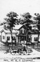
| Date: | 1873 |
|---|---|
| Description: | Engraved view of the W.P. Storms residence, with a horse-drawn wagon in front traveling along the road. Caption reads: "Res. of W.P. Storms Sec 13 Spring P... |
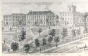
| Date: | 1873 |
|---|---|
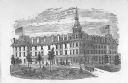
| Description: | View of several buildings on the grounds of Ripon College. Caption reads: "Ripon College, Ripon City, Wis." |
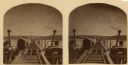
| Date: | 1873 |
|---|---|
| Description: | Stereograph of John Lawler's pile-pontoon railway bridge over both channels of the Mississippi River at Prairie du Chien, and McGregor, Iowa. East draw, 39... |

| Date: | 1873 |
|---|---|
| Description: | Portion of Winnebago County map showing Lake Winneconne and the Wolf River. |

| Date: | 1873 |
|---|---|
| Description: | Color outline map of Dane County, Wisconsin. |
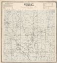
| Date: | 1873 |
|---|---|
| Description: | A map of Verona Township from the Dane County Atlas. |
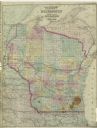
| Date: | 1873 |
|---|---|
| Description: | A map of Wisconsin along with southeastern Minnesota and Iowa, northern Illinois and the Upper Peninsula of Michigan, showing the counties, county seats, v... |

| Date: | 1873 |
|---|---|
| Description: | A hand-colored map of Minnesota, Wisconsin, and Michigan shows the counties, cities, villages, rivers, lakes, railroads, and steamboat routes in these stat... |

| Date: | 1873 |
|---|---|
| Description: | A hand-colored, geological map of the Fox and Wisconsin rivers’ water path from the Mississippi River to the Great Lakes. The map also shows those railroad... |

| Date: | 1873 |
|---|---|
| Description: | Map of Wisconsin showing counties, county seats, cities with populations over 3,000, and congressional districts. The map also includes rivers, lakes, rail... |

| Date: | 1873 |
|---|---|
| Description: | This hand-colored map of Wisconsin depicts the township survey grid and identifies counties, named towns, cities and villages, rivers, lakes, railroads, an... |

| Date: | 1873 |
|---|---|
| Description: | This hand-colored map of Wisconsin shows the township grid, railroads and proposed railroads, counties, cities, villages, and post offices. Population tabl... |
If you didn't find the material you searched for, our Library Reference Staff can help.
Call our reference desk at 608-264-6535 or email us at: