 Filter: Categories of Wisconsin Historical Images
Filter: FULL_DATE of 1873
Filter: Subject of dams
Filter: Categories of Wisconsin Historical Images
Filter: FULL_DATE of 1873
Filter: Subject of dams

| Date: | 1873 |
|---|---|
| Description: | Engraved image of a lock and dam at Sault St. Marie. Two men are operating the sluice as ships are waiting on the opposite side of the lock. Another man is... |
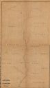
| Date: | 1873 |
|---|---|
| Description: | This 1873 map shows Clark County, Wisconsin, as well as the portion of Taylor County that was then part of Clark. The township and range grid, sections, ra... |

| Date: | 1873 |
|---|---|
| Description: | This 1873 map of Chippewa County, Wisconsin, which at the time also encompassed all or part of Price, Rusk, Sawyer, and Taylor counties, shows the township... |
If you didn't find the material you searched for, our Library Reference Staff can help.
Call our reference desk at 608-264-6535 or email us at: