 Filter: Categories of Wisconsin Historical Images
Filter: FULL_DATE of 1873
Filter: Subject of cemeteries
Filter: Categories of Wisconsin Historical Images
Filter: FULL_DATE of 1873
Filter: Subject of cemeteries
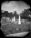
| Date: | 1873 |
|---|---|
| Description: | Women with parasols in Oak Hill Cemetery. Thomas and Hannah Robinson's tombstones can be seen. |
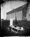
| Date: | 1873 |
|---|---|
| Description: | Norwegian-American farm laborer, Hans Christianson (age 44), stands next to the grave of his childless wife, Karen Luis Christianson, born 1829, who died J... |

| Date: | 1873 |
|---|---|
| Description: | This 1874 map of Washington and Ozaukee counties, Wisconsin, shows the township and range grid, towns, sections, cities and villages, rural landownership a... |

| Date: | 1873 |
|---|---|
| Description: | This 1873 map of Winnebago County, Wisconsin, shows the township and range grid, towns, sections, cities and villages, landownership and acreages, roads, r... |

| Date: | 1873 |
|---|---|
| Description: | Map shows townships and sections, landownership and acreages, state and county lands, churches, schools, cemeteries, roads, and railroads. There is an inse... |

| Date: | 1873 |
|---|---|
| Description: | This map shows land ownership by name, local streets, railroads, parks, college grounds, schools, cemeteries, and part of Rock River. The upper left margin... |
If you didn't find the material you searched for, our Library Reference Staff can help.
Call our reference desk at 608-264-6535 or email us at: