Filter: Categories of Wisconsin Historical Images
Filter: FULL_DATE of 1873
Filter: Type of Map or Atlas
Filter: Subject of transportation
Filter: County of Dane
Filter: Categories of Wisconsin Historical Images
Filter: FULL_DATE of 1873
Filter: Type of Map or Atlas
Filter: Subject of transportation
Filter: County of Dane

| Date: | 1873 |
|---|---|
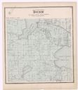
| Description: | Map of the township of Windsor, from the "Atlas of Dane County." |

| Date: | 1873 |
|---|---|
| Description: | Color outline map of Dane County, Wisconsin. |

| Date: | 1873 |
|---|---|
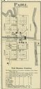
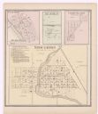
| Description: | This map shows lots and blocks, additions and subdivisions, and large-scale landownership. The map is oriented with north to the upper right. The map is fr... |

| Date: | 1873 |
|---|---|
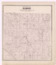
| Description: | A map of the township of Primrose from the "Atlas of Dane County." |

| Date: | 1873 |
|---|---|
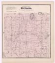
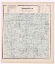
| Description: | A map of the township of Montrose from the "Atlas of Dane County." |
| Date: | 1873 |
|---|---|
| Description: | A page showing four plat maps: Stoughton, Clifton, Deanville, and Cross Plains. |
| Date: | 1873 |
|---|---|
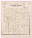
| Description: | A plat map of the town of Pleasant Springs. |
If you didn't find the material you searched for, our Library Reference Staff can help.
Call our reference desk at 608-264-6535 or email us at: