 Filter: Categories of Wisconsin Historical Images
Filter: FULL_DATE of 1872
Filter: Year of 1800-1899
Filter: Subject of ships
Filter: Categories of Wisconsin Historical Images
Filter: FULL_DATE of 1872
Filter: Year of 1800-1899
Filter: Subject of ships

| Date: | 1872 |
|---|---|
| Description: | Bird's-eye map of Milwaukee on Lake Michigan. |

| Date: | 1872 |
|---|---|
| Description: | Birds-eye drawing of Eau Claire depicts street names and street locations, houses, trees, bridges, piers, canals, railroads, and the Chippewa and Eau Clair... |
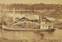
| Date: | 1872 |
|---|---|
| Description: | Elevated view from hill of the freight steamer "Cornucopia" loading hides at the Hammond Brothers warehouse, with Lawrence University buildings on the hill... |

| Date: | 1872 |
|---|---|
| Description: | A map of Wisconsin which shows the counties, county seats, those cities with over 3,000 inhabitants. The map also displays the rivers, lakes, completed and... |

| Date: | 1872 |
|---|---|
| Description: | This map includes depth shown by soundings and isolines and relief shown by contours. Tree species and locations are labeled, as well as a cranberry meadow... |
If you didn't find the material you searched for, our Library Reference Staff can help.
Call our reference desk at 608-264-6535 or email us at: