 Filter: Categories of Wisconsin Historical Images
Filter: FULL_DATE of 1872
Filter: Subject of log transportation
Filter: Categories of Wisconsin Historical Images
Filter: FULL_DATE of 1872
Filter: Subject of log transportation

| Date: | 1872 |
|---|---|
| Description: | Birds-eye drawing of Eau Claire depicts street names and street locations, houses, trees, bridges, piers, canals, railroads, and the Chippewa and Eau Clair... |

| Date: | 1872 |
|---|---|
| Description: | Map of the Chippewa River, from the head of navigation at the city of Chippewa Falls, covering a distance of 16 miles above : showing the established impro... |
| Date: | 1872 |
|---|---|
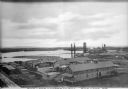
| Description: | Elevated view of the Rice Lake Lumber Company Mill, taken from a high vantage point. A formation of logs is in the river, and piles of finished boards are ... |
| Date: | 1872 |
|---|---|
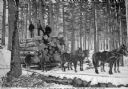
| Description: | A group of men use a team of four horses to transport logs across snow-covered ground on a sled. Trees are in the background. Caption reads: "A Logging Sce... |
| Date: | 1872 |
|---|---|
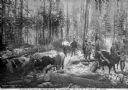
| Description: | A group of loggers poses for a group portrait amongst cut logs in a snow-covered wooded area. The men in the middle have their axes in hand, while other me... |
If you didn't find the material you searched for, our Library Reference Staff can help.
Call our reference desk at 608-264-6535 or email us at: