 Filter: Categories of Wisconsin Historical Images
Filter: FULL_DATE of 1872
Filter: Subject of church buildings
Filter: Categories of Wisconsin Historical Images
Filter: FULL_DATE of 1872
Filter: Subject of church buildings

| Date: | 1872 |
|---|---|
| Description: | Birds-eye drawing of Eau Claire depicts street names and street locations, houses, trees, bridges, piers, canals, railroads, and the Chippewa and Eau Clair... |

| Date: | 1872 |
|---|---|
| Description: | View of the Spring Prairie Lutheran Church, built in 1853 and replaced in 1886. |
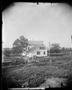
| Date: | 1872 |
|---|---|
| Description: | Men sit on farm machinery at the side of the parsonage of the St. Paul Liberty Church. The church is visible in the distance. The town of Deerfield is fou... |
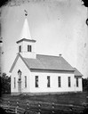
| Date: | 1872 |
|---|---|
| Description: | East Blue Mounds Lutheran Church, built in 1868. The church was formerly the Norsk Evangelisk Lutheranisk Kirke. |
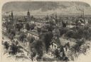
| Date: | 1872 |
|---|---|
| Description: | Elevated view over residential area, with several churches in the background. |

| Date: | 1872 |
|---|---|
| Description: | Shows townships and sections, landownership and acreages, roads, railroads, churches, schools, and cemeteries. Includes business directories of Manitowoc ... |

| Date: | 1872 |
|---|---|
| Description: | Map shows townships and sections, landownership, roads, railroads, churches, schools, and cemeteries. The map includes business directories of Watertown, J... |
If you didn't find the material you searched for, our Library Reference Staff can help.
Call our reference desk at 608-264-6535 or email us at: